
Maps Collection
Gabon is a country located in Central Africa, bordered by Equatorial Guinea
Choose a picture from our Maps Collection for your Wall Art and Photo Gifts
11 items

All Professionally Made to Order for Quick Shipping
-
Maps Collection
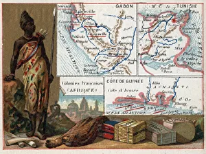
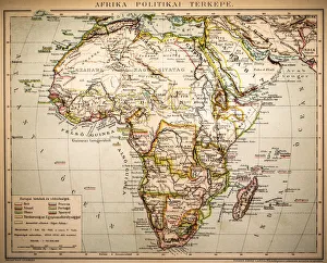
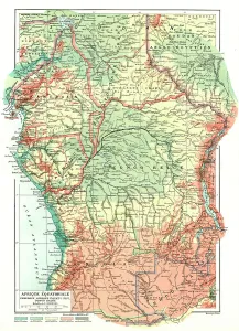
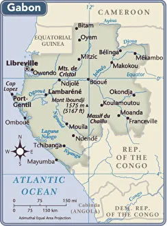
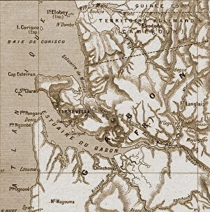
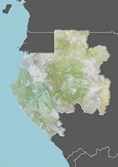
Gabon is a country located in Central Africa, bordered by Equatorial Guinea, Cameroon and the Republic of Congo and has an area of 267,667 square kilometres and a population of approximately 1.8 million people. The capital city is Libreville. Gabon is known for its diverse landscapes, ranging from dense rainforests to savannahs and beaches along the Atlantic coast. It also has many rivers and lakes that are important sources of water for the local population. Maps of Gabon show its varied terrain as well as its major cities and towns, roads, railways, airports and ports. The country's main exports include crude oil, timber products such as mahogany wood and manganese ore; while imports include machinery equipment, foodstuffs such as rice and wheat flour; chemicals; vehicles; fuel oil; iron ore; textiles; pharmaceuticals etc.
+
Our beautiful pictures are available as Framed Prints, Photos, Wall Art and Photo Gifts
The Maps of Gabon Africa collection from Media Storehouse is a stunning selection of wall art and framed prints that showcase the beauty and diversity of Gabon, a country located in Central Africa. Our collection features an array of maps that highlight the various regions, cities, and landmarks within Gabon, including its national parks, rivers, and mountains. These maps are not only visually appealing but also informative for those interested in learning more about this fascinating African nation. Each print is carefully crafted using high-quality materials to ensure longevity and durability. Customers can choose from a range of sizes to suit their individual needs and preferences. Whether you're looking to add some color to your home or office space or simply want to learn more about Gabon's geography, the Maps of Gabon Africa collection has something for everyone. With its unique blend of artistry and information, our collection is sure to impress both casual viewers and serious collectors alike.
+
What are Maps of Gabon Africa art prints?
Maps of Gabon Africa art prints are high-quality reproductions of maps that depict the geography, topography, and landmarks of Gabon, a country located in Central Africa. These art prints showcase the intricate details and features of the region's terrain, including rivers, mountains, forests, and cities. These maps are not only informative but also visually appealing as they come in various styles such as vintage or modern designs. They can be used for educational purposes or as decorative pieces to add character to any room. We offer a wide range of Maps of Gabon Africa art prints that cater to different preferences and needs. You can choose from various sizes and framing options to suit their taste and budget. Whether you're an avid traveler or simply looking for unique wall decor ideas, these art prints are perfect additions to your collection. With our extensive selection and excellent quality standards, you can enjoy stunning Map Art Prints at affordable prices without compromising on quality.
+
What Maps of Gabon Africa art prints can I buy from Media Storehouse?
We offer a wide range of Maps of Gabon Africa art prints that are perfect for anyone who loves African culture and geography. These maps showcase the beautiful landscapes, rivers, and cities of Gabon in stunning detail, making them ideal for use as educational tools or decorative pieces. Some of the most popular Maps of Gabon Africa art prints available from Media Storehouse include vintage-style maps that feature intricate illustrations and detailed descriptions of the country's regions and landmarks. Other options include modern satellite images that provide a more accurate representation of the country's current topography. Whether you're looking to add some color to your home or office decor, or simply want to learn more about this fascinating African nation, we have a variety of Maps of Gabon Africa art prints to choose from. So why not explore our collection today and find the perfect print for your needs?
+
How do I buy Maps of Gabon Africa art prints?
To buy Maps of Gabon Africa art prints from Media Storehouse, you can browse our extensive collection of maps and select the one that catches your eye. Once you have found the map you want to purchase, simply click on it and follow the prompts to add it to your cart. You will then be prompted to enter your shipping and payment information before completing your order. We offer a variety of sizes for their Maps of Gabon Africa art prints, so make sure to choose the size that best fits your needs. Additionally, we offer different framing options if you prefer a framed print. Buying Maps of Gabon Africa art prints from Media Storehouse is an easy process with just a few clicks required. With their vast selection and high-quality printing techniques, you are sure to find a beautiful piece that will enhance any room in which it is displayed.
+
How much do Maps of Gabon Africa art prints cost?
As a provider of art prints, we offer a wide range of maps of Gabon Africa at varying prices. The cost depends on several factors such as the size and type of print selected by the customer. Generally, smaller sizes tend to be more affordable while larger ones are priced higher due to their increased production costs. Additionally, different types of prints may also affect the price point, with some options being more expensive than others. It is worth noting that Media Storehouse strives to offer competitive pricing for all its products without compromising on quality. You can expect high-quality maps of Gabon Africa art prints that are both visually appealing and durable. With an extensive collection available online, you can browse through various options before making a purchase decision based on their preferences and budget. We provide excellent value for money when it comes to purchasing maps of Gabon Africa art prints.
+
How will my Maps of Gabon Africa art prints be delivered to me?
Your Maps of Gabon Africa art prints will be delivered to you in a safe and secure manner. We take great care in packaging your artwork so that it arrives at your doorstep undamaged. Our standard delivery method is through postal services, which means that your print will be shipped directly to the address you provide during checkout. We use high-quality materials for our packaging to ensure that your artwork is protected from any potential damage during transit. Your print will arrive rolled up in a sturdy tube, which prevents creases or folds on the surface of the paper. Once you receive your package, carefully remove the print from its protective tube and lay it flat on a clean surface. You can then frame it or display it as desired. We are committed to providing our customers with exceptional service and quality products. We hope that you enjoy your Maps of Gabon Africa art prints for years to come.