
Maps Collection
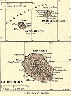
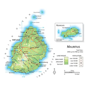
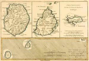
Mauritius is an island nation located in the Indian Ocean off the east coast of Africa, and is known for its beautiful beaches, lush forests
Choose a picture from our Maps Collection for your Wall Art and Photo Gifts
23 items


All Professionally Made to Order for Quick Shipping
-
Maps Collection
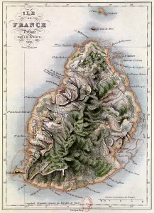
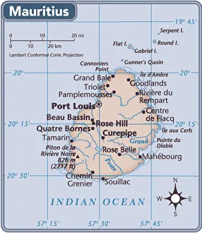
Mauritius is an island nation located in the Indian Ocean off the east coast of Africa, and is known for its beautiful beaches, lush forests, and vibrant culture. The country has a long history of exploration and colonization by Europeans, beginning with the Portuguese in 1507. Mauritius has a diverse geography that includes mountains, coral reefs, lagoons, and wetlands. Its capital city is Port Louis. Maps of Mauritius are available to explore its many features including roads and highways, rivers and lakes, cities and townships as well as national parks and reserves. These maps provide insight into the unique landscape of this African nation which has been shaped by centuries of human activity. They also offer visitors an opportunity to plan their trip around this fascinating destination with ease.
+
Our beautiful pictures are available as Framed Prints, Photos, Wall Art and Photo Gifts
The Maps of Mauritius Africa collection from Media Storehouse is a stunning assortment of wall art and framed prints that showcase the beauty and diversity of this African island nation. Our collection features an extensive range of maps, including vintage maps dating back to the 18th century as well as contemporary ones highlighting the country's topography, landmarks, and attractions. Each print in our collection is carefully crafted using high-quality materials that ensure longevity and durability. Customers can choose from a variety of sizes and framing options to suit their specific needs. Whether you're looking for a unique piece to decorate your home or office or want to gift someone special with a one-of-a-kind present, our collection has something for everyone. The Maps of Mauritius Africa collection offers an excellent opportunity to explore the rich history and culture of this fascinating country through beautiful artwork that captures its essence perfectly.
+
What are Maps of Mauritius Africa art prints?
Maps of Mauritius Africa art prints are high-quality reproductions of maps that depict the island nation of Mauritius, located in the Indian Ocean off the southeast coast of Africa. These prints showcase a variety of different map styles and designs, ranging from antique and vintage maps to modern and contemporary ones. These art prints are perfect for anyone who loves geography, history or travel. They can be used as decorative pieces in homes, offices or classrooms, or as educational tools for students studying African geography or history. Maps of Mauritius Africa art prints come in a range of sizes to suit any space and decor style. They are printed on premium quality paper using state-of-the-art printing technology to ensure vibrant colours and sharp details. Whether you're looking to add some colour to your walls or want to learn more about this fascinating part of the world, Maps of Mauritius Africa art prints offer an affordable way to do both.
+
What Maps of Mauritius Africa art prints can I buy from Media Storehouse?
We offer a wide range of Maps of Mauritius Africa art prints that are perfect for those who love to explore and learn about the geography of this beautiful island nation. These maps come in various styles, including vintage, antique, and modern designs. You can choose from different sizes and materials such as canvas or framed prints to suit your preferences. Some popular options include detailed topographic maps that showcase the terrain features of Mauritius, political maps that highlight the country's administrative divisions, and historical maps that depict how the island has evolved over time. Whether you're looking for a decorative piece for your home or office or an educational tool for your classroom or library, we have something to offer. With high-quality printing technology and excellent customer service, you can trust Media Storehouse to provide you with beautiful Maps of Mauritius Africa art prints that will last a lifetime.
+
How do I buy Maps of Mauritius Africa art prints?
To buy Maps of Mauritius Africa art prints from Media Storehouse, you can browse our extensive collection online. Simply search for "Maps of Mauritius" or "Africa art prints" on our website and select the print that catches your eye. Once you have found the perfect print, add it to your cart and proceed to checkout. During checkout, you will be prompted to enter your shipping and payment information. Be sure to review all details before submitting your order. We offer a variety of sizes and framing options for their art prints, so make sure to choose the one that best fits your needs. Whether you're looking for a small print to hang in your home office or a large statement piece for your living room, we have something for everyone. Buying Maps of Mauritius Africa art prints from Media Storehouse is simple and straightforward. With high-quality prints at affordable prices, it's easy to add some beautiful artwork to any space in no time.
+
How much do Maps of Mauritius Africa art prints cost?
We offer a wide range of Maps of Mauritius Africa art prints that cater to different tastes and preferences. The cost of these prints varies depending on the size, quality, and type of print you choose. We have affordable options for those on a budget as well as premium options for those looking for high-quality prints. Our Maps of Mauritius Africa art prints are available in various sizes ranging from small to large formats. You can choose between framed or unframed prints depending on your preference. Our collection includes vintage maps, contemporary designs, and artistic interpretations that capture the beauty and essence of Mauritius. We take pride in offering our customers top-notch products at competitive prices without compromising on quality. Whether you're looking to decorate your home or office space with stunning artwork or gift someone special with a unique piece, our Maps of Mauritius Africa art prints are an excellent choice that won't break the bank.
+
How will my Maps of Mauritius Africa art prints be delivered to me?
We take great care in delivering your Maps of Mauritius Africa art prints to you. We use high-quality packaging materials to ensure that your artwork arrives in perfect condition. Your print will be carefully rolled and placed in a sturdy tube for shipping. This method ensures that the print is protected during transit and prevents any damage from occurring. We work with trusted delivery partners who are experienced in handling delicate items such as art prints. Once your order has been dispatched, you will receive a tracking number so you can keep an eye on its progress. When your Maps of Mauritius Africa art print arrives, it's important to handle it with care when unrolling it from the tube. We recommend laying the print flat for a few hours before framing or hanging it up. At Media Storehouse, we're committed to providing our customers with high-quality products and excellent customer service every step of the way.