
Maps Collection
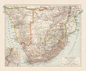
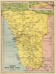
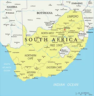
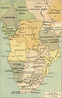
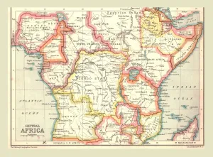
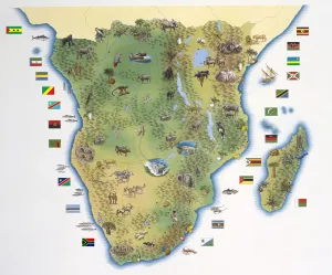
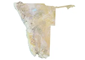
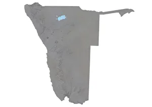
Namibia is a country located in southern Africa, bordered by Angola, Botswana, South Africa and Zambia
Choose a picture from our Maps Collection for your Wall Art and Photo Gifts
23 items

All Professionally Made to Order for Quick Shipping
-
Maps Collection
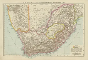
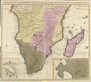
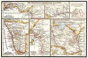
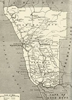
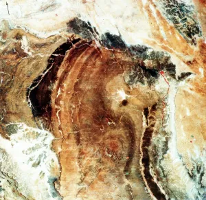
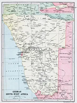
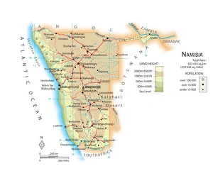
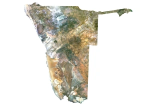
Namibia is a country located in southern Africa, bordered by Angola, Botswana, South Africa and Zambia, and is the second least densely populated country in the world. Maps of Namibia provide an overview of its geography and topography. The terrain consists of mostly desert and savanna grasslands with some mountains in the northeast corner. The Kunene River forms part of the border between Namibia and Angola while other major rivers include the Orange River which flows through much of Namibia's central region, as well as the Okavango Delta which forms part of Botswana's northern border with Namibia. It also shows that there are several national parks such as Etosha National Park which is home to many species of wildlife including elephants, lions, cheetahs and rhinos; Fish River Canyon; Sossusvlei Desert; Skeleton Coast National Park; Kaudom Game Reserve; Waterberg Plateau Park; etc. It also indicate that there are several cities located throughout Namibia including Windhoek (the capital), Swakopmund on the Atlantic coast, Walvis Bay on a lagoon near Swakopmund and Tsumeb in northern Namibia near Etosha National Park.
+
Our beautiful pictures are available as Framed Prints, Photos, Wall Art and Photo Gifts
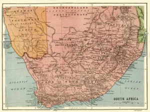
Media Storehouse offers a stunning collection of Maps of Namibia Africa, featuring high-quality wall art and framed prints. Our collection showcases the diverse geography and topography of Namibia, including its deserts, mountains, rivers, and wildlife reserves. Each map is intricately detailed with accurate cartographic information that highlights the country's unique features. The Maps of Namibia Africa collection includes vintage maps from as early as the 19th century to contemporary designs that reflect modern-day changes in infrastructure and urbanization. These maps are perfect for anyone interested in exploring or studying Namibia's history or geography. Whether you're looking to decorate your home or office space with beautiful artwork or seeking educational resources for research purposes, Media Storehouse has something for everyone. With a wide range of sizes and framing options available at affordable prices, our collection is an excellent choice for anyone who wants to add a touch of African beauty to their walls.
+
What are Maps of Namibia Africa art prints?
Maps of Namibia Africa art prints are high-quality reproductions of maps that depict the geography and topography of Namibia, a country located in southern Africa. These art prints are created using advanced printing techniques to ensure that they capture every detail and nuance of the original map. These maps can be used for decorative purposes or as educational tools, providing a unique way to learn about the history and geography of Namibia. They are ideal for anyone who has an interest in African culture, travel or exploration. Maps of Namibia Africa art prints come in a variety of sizes and styles, making them suitable for any room or decor scheme. Whether you're looking for something bold and eye-catching or subtle and understated, there is sure to be a print that suits your taste. Maps of Namibia Africa art prints offer a fascinating glimpse into one of the world's most intriguing countries. With their intricate details and beautiful designs, they make excellent additions to any home or office space.
+
What Maps of Namibia Africa art prints can I buy from Media Storehouse?
We offer a wide range of Namibia Africa art prints that are perfect for adding a touch of African beauty to your home or office. You can choose from various maps of Namibia, including detailed topographical maps, political maps, and vintage-style maps. These high-quality prints feature stunning colors and intricate details that capture the unique landscape and culture of this beautiful country. In addition to traditional paper prints, Media Storehouse also offers canvas prints that are stretched over wooden frames for a more contemporary look. You can also opt for framed prints in various sizes and styles to suit your decor preferences. Whether you're looking for a statement piece to hang on your living room wall or an inspiring image to decorate your workspace, we have something for everyone. With our extensive collection of Namibia Africa art prints, you're sure to find the perfect piece that will bring joy and inspiration into your life.
+
How do I buy Maps of Namibia Africa art prints?
To buy Maps of Namibia Africa art prints from Media Storehouse, you can browse our extensive collection of maps and select the one that catches your eye. Once you have found the map you want to purchase, simply add it to your cart and proceed to checkout. At checkout, enter your shipping information and payment details to complete the transaction. We offer a variety of sizes for their art prints, so be sure to choose the size that best fits your needs. Their high-quality printing process ensures that each print is vibrant and detailed, making them perfect for display in any home or office. If you are looking for a unique gift idea or just want to add some beautiful artwork to your space, Maps of Namibia Africa art prints from Media Storehouse are an excellent choice. With easy online ordering and fast shipping options available, it has never been easier to bring stunning artwork into your life.
+
How much do Maps of Namibia Africa art prints cost?
We offer a wide range of Maps of Namibia Africa art prints that vary in price depending on the size and type of print. Our collection includes vintage maps, modern designs, and satellite images that capture the beauty and diversity of Namibia's landscape. We have options for every budget, from affordable poster prints to high-quality canvas prints that are perfect for framing or hanging as wall decor. Our art prints are produced using state-of-the-art printing technology to ensure vibrant colors and sharp details that will last a lifetime. Whether you're looking to add some African flair to your home or office space or searching for a unique gift idea, our Maps of Namibia Africa art prints are an excellent choice at competitive prices.
+
How will my Maps of Namibia Africa art prints be delivered to me?
We take great care in ensuring that your Maps of Namibia Africa art prints are delivered to you in the best possible condition. We use high-quality packaging materials and reliable shipping methods to ensure that your order arrives safely and securely. Your Maps of Namibia Africa art prints will be carefully rolled up and placed inside a sturdy cardboard tube for protection during transit. The tube will then be sealed with tape to prevent any damage or moisture from getting inside. Once your order has been shipped, you will receive a tracking number so that you can keep an eye on its progress. Delivery times may vary depending on your location, but we aim to get your order to you as quickly as possible. We hope that you enjoy your Maps of Namibia Africa art prints and appreciate our efforts in delivering them safely to you.