
Maps Collection
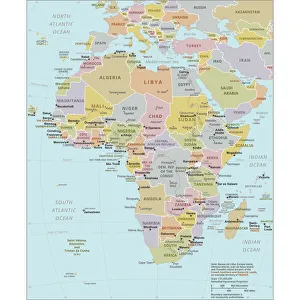
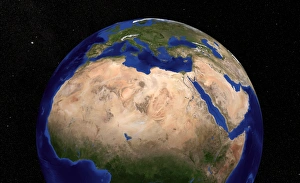
South Sudan is the world’s newest country, located in East-Central Africa, and is bordered by Sudan to the north, Ethiopia to the east
Choose a picture from our Maps Collection for your Wall Art and Photo Gifts
18 items


All Professionally Made to Order for Quick Shipping
-
Maps Collection
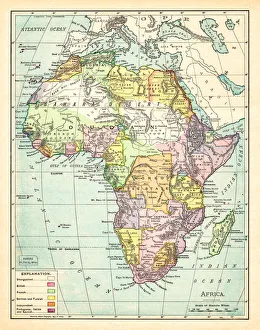
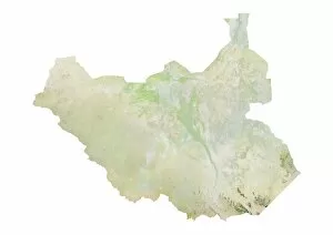
South Sudan is the world’s newest country, located in East-Central Africa, and is bordered by Sudan to the north, Ethiopia to the east, Kenya to the southeast, Uganda to the south and Democratic Republic of Congo to the west. Maps of South Sudan show its diverse terrain which includes swamps, grasslands and tropical forests. The White Nile River runs through it from north to south and Lake Albert lies on its western border with DRC. Its capital city Juba is located in Central Equatoria State near where White Nile meets Bahr el Jebel River. South Sudan has a population of 12 million people who are mainly subsistence farmers living in rural areas with limited access to healthcare or education services. Despite this poverty, there are many natural resources including oil reserves which have been exploited since 2011 when South Sudan gained independence from Sudan.
+
Our beautiful pictures are available as Framed Prints, Photos, Wall Art and Photo Gifts
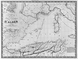
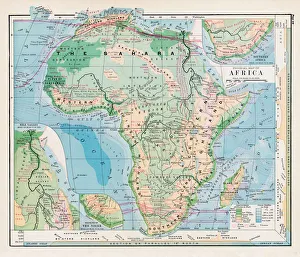
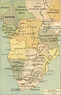
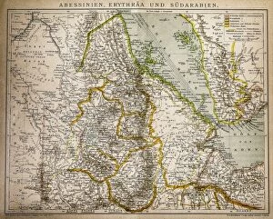
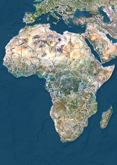
The Maps of South Sudan Africa collection is a series of wall art and framed prints offered by Media Storehouse. Our collection features a range of maps that showcase the geography, topography, and political boundaries of South Sudan. These maps are created using high-quality printing techniques to ensure that they are clear, detailed, and accurate. The Maps of South Sudan Africa collection includes both historical and contemporary maps, providing a comprehensive overview of the country's development over time. Some examples include antique maps from the 19th century as well as modern satellite imagery. These prints are perfect for anyone interested in African history or geography, or for those who simply want to add some unique artwork to their home or office decor. They make great gifts for students studying African studies or international relations. The Maps of South Sudan Africa collection offers an excellent opportunity to explore this fascinating country through its cartography.
+
What are Maps of South Sudan Africa art prints?
Maps of South Sudan Africa art prints are high-quality reproductions of maps that depict the geography and topography of South Sudan, a country located in East-Central Africa. These maps showcase the various regions, cities, towns, rivers, lakes and other landmarks within the country's borders. These art prints are perfect for anyone who is interested in African history or geography. They can be used to decorate homes or offices with an educational touch. Maps of South Sudan Africa art prints come in different sizes and styles to suit individual preferences. Some people may choose to display these maps as standalone pieces while others may prefer to frame them alongside other artworks or photographs. Regardless of how they are displayed, Maps of South Sudan Africa art prints offer a unique way to celebrate this fascinating region's culture and heritage through visual representation.
+
What Maps of South Sudan Africa art prints can I buy from Media Storehouse?
We offer a wide range of Maps of South Sudan Africa art prints that you can buy. These maps are available in different sizes and styles, including vintage, antique, and modern designs. You can choose from various types of maps such as political maps, physical maps, topographical maps, and more. The Maps of South Sudan Africa art prints showcase the country's diverse geography with its vast savannahs, wetlands, mountains ranges and rivers. They also highlight important landmarks like national parks, cities and towns. Whether you're looking for a decorative piece to hang on your wall or an educational tool for your classroom or office space Media Storehouse has got you covered. The high-quality printing process ensures that every detail is captured accurately so that you can enjoy these beautiful works of art for years to come. So why not explore our collection today and find the perfect Map of South Sudan Africa art print that suits your style?
+
How do I buy Maps of South Sudan Africa art prints?
If you're looking to buy Maps of South Sudan Africa art prints, Media Storehouse is a great place to start. We offer a wide selection of high-quality prints that are perfect for anyone who loves African art and culture. To purchase your print, simply browse through the available options on our website and select the one that best fits your preferences. Once you've made your choice, add it to your cart and proceed to checkout. At checkout, you'll be prompted to enter your shipping information and payment details. After completing these steps, all that's left is to wait for your print to arrive at your doorstep. Whether you're looking for a unique piece of artwork for yourself or as a gift for someone else, we have something for everyone. So why not explore our collection today and find the perfect Maps of South Sudan Africa art print?
+
How much do Maps of South Sudan Africa art prints cost?
We offer a wide range of Maps of South Sudan Africa art prints that vary in price depending on the size and type of print. Our collection includes vintage maps, contemporary designs, and satellite images that capture the beauty and diversity of this African nation. We work with a variety of artists and photographers to ensure that our customers have access to high-quality prints that are both visually stunning and informative. Our Maps of South Sudan Africa art prints are available in various sizes ranging from small to large formats. We offer different types of paper finishes such as glossy or matte, which can affect the overall cost. Additionally, some prints may be more expensive due to their rarity or unique features. Our prices for Maps of South Sudan Africa art prints are competitive within the market while still maintaining excellent quality standards. You can browse through our selection online or contact us directly for any further inquiries about pricing or availability.
+
How will my Maps of South Sudan Africa art prints be delivered to me?
Your Maps of South Sudan Africa art prints will be delivered to you in a secure and safe manner. We use reliable shipping partners who ensure that your package arrives at your doorstep without any damage or delay. Our packaging is designed to protect the artwork from any external factors that may cause harm during transit. We offer various delivery options depending on your location, including standard and express delivery services. You can choose the option that suits you best during checkout. Once your order has been dispatched, we will send you an email with tracking information so that you can monitor its progress until it reaches you. If for any reason there are issues with delivery, our customer service team is always available to assist and resolve any concerns promptly. We take pride in delivering high-quality products and exceptional customer service. We look forward to providing you with a seamless experience when receiving your Maps of South Sudan Africa art prints.