
Maps Collection
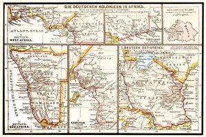
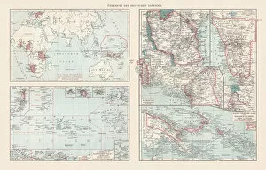
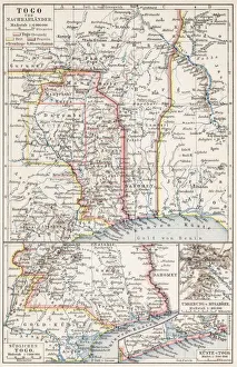
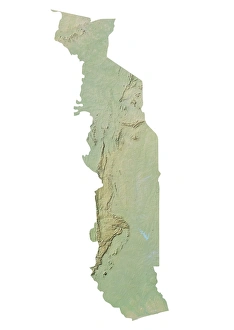
Togo is a small country in West Africa
Choose a picture from our Maps Collection for your Wall Art and Photo Gifts
16 items


All Professionally Made to Order for Quick Shipping
-
Maps Collection
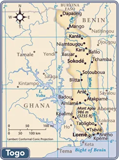
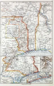
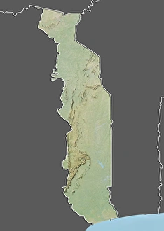
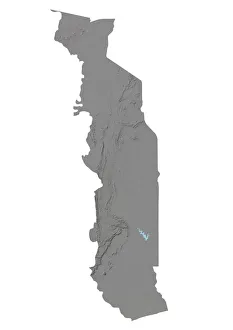
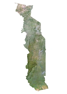
Togo is a small country in West Africa, located between Ghana and Benin and has a population of approximately 8 million people and covers an area of 56,785 square kilometers. The terrain is mostly flat with some hills in the north and south. The climate is tropical with two rainy seasons from April to July and September to November. Togo's main geographical features include Lake Togo, the Mono River, Mount Agou (the highest point in the country), and several national parks. Maps of Togo are available from various sources including online maps such as Google Maps or OpenStreetMap, as well as physical maps from bookstores or tourist offices. These maps provide detailed information about roads, cities, rivers, lakes and other geographical features that make up this fascinating African nation.
+
Our beautiful pictures are available as Framed Prints, Photos, Wall Art and Photo Gifts
Media Storehouse offers a collection of Maps of Togo Africa, which features a variety of vintage and contemporary maps showcasing the geography, topography, and political boundaries of the West African country. Our collection includes detailed maps that highlight major cities, rivers, lakes, mountains, and other landmarks in Togo. These maps are available as wall art or framed prints in different sizes to suit various spaces and preferences. The Maps of Togo Africa collection is an excellent resource for historians, geographers, travelers or anyone interested in learning more about this fascinating country. They can be used to decorate homes or offices while also serving as educational tools for schools or libraries. Whether you're looking for a unique gift idea or want to add some cultural flair to your decor theme; our Maps of Togo Africa collection has something for everyone who appreciates cartography artistry.
+
What are Maps of Togo Africa art prints?
Maps of Togo Africa art prints are a collection of beautifully designed and detailed maps that showcase the geography, topography, and landmarks of Togo. These prints are created using high-quality printing techniques to ensure that every detail is captured with precision and accuracy. These art prints serve as an excellent decorative piece for homes or offices, providing a unique way to display one's love for Togo. They also make great gifts for those who have an interest in geography or African culture. The Maps of Togo Africa art prints come in various sizes and styles, including vintage maps, modern designs, and colorful illustrations. Each print is made using archival-grade paper to ensure long-lasting quality. These art prints offer a beautiful way to celebrate the beauty and diversity of Togo while adding a touch of elegance to any space they adorn.
+
What Maps of Togo Africa art prints can I buy from Media Storehouse?
We offer a wide range of Maps of Togo Africa art prints that you can purchase. These maps are available in various sizes and styles, including vintage, antique, and contemporary designs. You can choose from different types of maps such as political, physical, topographical or road maps. The Maps of Togo Africa art prints showcase the beautiful landscapes and geographical features of this West African country. From the coastlines to the savannahs and forests, these maps provide an insight into the diverse terrain that makes up Togo. Whether you're looking for a decorative piece for your home or office or want to use it for educational purposes, we have got you covered with our extensive collection of Maps of Togo Africa art prints. With high-quality printing techniques used on premium materials like canvas or paper stock, these prints are sure to impress anyone who sees them.
+
How do I buy Maps of Togo Africa art prints?
To buy Maps of Togo Africa art prints from Media Storehouse, you can browse our online collection of artwork and select the specific print that you are interested in purchasing. Once you have found the print that you want to buy, simply add it to your cart and proceed to checkout. During checkout, you will be prompted to provide your shipping information and payment details. We offer a wide range of high-quality art prints featuring maps of Togo Africa created by talented artists from around the world. Whether you are looking for a colorful map depicting the country's topography or a more detailed representation of its cities and landmarks, we have something for everyone. Our easy-to-use website makes it simple to find and purchase the perfect piece of artwork for your home or office. So if you're looking for beautiful Maps of Togo Africa art prints, look no further than Media Storehouse.
+
How much do Maps of Togo Africa art prints cost?
We offer a wide range of Maps of Togo Africa art prints at varying prices. Our collection includes high-quality prints that are perfect for adding character and style to any space. The cost of our Maps of Togo Africa art prints depends on various factors such as the size, framing options, and printing material. We have different sizes available ranging from small to large formats which cater to different budgets. Our you can choose from a variety of printing materials including fine art paper, canvas or photographic paper depending on their preference. Each print is carefully crafted using state-of-the-art technology ensuring that it meets the highest quality standards. We take pride in offering affordable yet premium quality products that meet the needs and preferences of our diverse customer base. Whether you're looking for a gift or something special for your home or office decor, we have something suitable for everyone's taste and budget.
+
How will my Maps of Togo Africa art prints be delivered to me?
We take great care in delivering your Maps of Togo Africa art prints to you. We use high-quality packaging materials to ensure that your print arrives in perfect condition. Depending on the size and quantity of prints ordered, they will be shipped either rolled up in a sturdy tube or flat-packed between protective layers. We work with trusted delivery partners who offer reliable and efficient services worldwide. Once your order has been dispatched, you will receive a tracking number so that you can follow its progress online. We are committed to providing our customers with an exceptional shopping experience from start to finish. If for any reason you are not satisfied with your purchase, please do not hesitate to contact us and we will do everything possible to resolve the issue promptly.