
Maps Collection
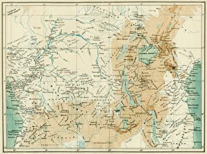
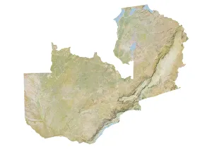
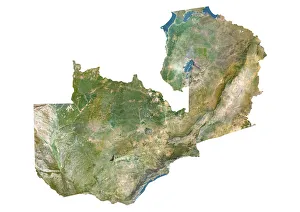
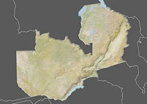
Zambia is a landlocked country in southern Africa, bordered by the Democratic Republic of Congo, Tanzania, Malawi, Mozambique, Zimbabwe
Choose a picture from our Maps Collection for your Wall Art and Photo Gifts
14 items

All Professionally Made to Order for Quick Shipping
-
Maps Collection
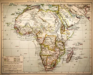
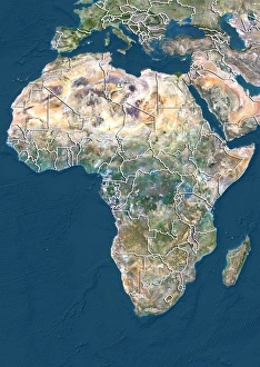
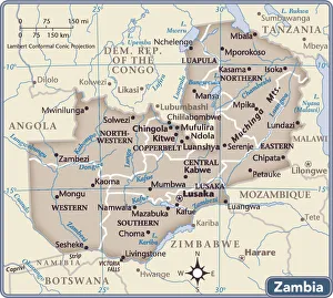
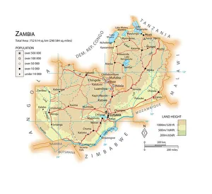
Zambia is a landlocked country in southern Africa, bordered by the Democratic Republic of Congo, Tanzania, Malawi, Mozambique, Zimbabwe, Botswana and Namibia and has a population of 17.3 million people and covers an area of 752 614 square kilometres. Maps of Zambia show the country’s diverse landscape ranging from high plateaus to low-lying plains. The capital city is Lusaka which lies in the south-central part of the country. Other major cities include Ndola in the north-central region and Kitwe in the Copperbelt Province. The main rivers are Zambezi and Kafue while Lake Tanganyika forms part of its eastern border with Tanzania and Burundi. Zambia has many national parks such as South Luangwa National Park which is home to a variety of wildlife including elephants, lions and leopards; North Luangwa National Park; Lower Zambezi National Park; Mosi-oa-Tunya National Park; Sioma Ngwezi National Park; Kafue National Park; Liuwa Plain National Park etc. It also shows that Zambia has abundant natural resources such as copper ore deposits as well as uranium reserves located mainly around Kariba Dam on the Zambezi River.
+
Our beautiful pictures are available as Framed Prints, Photos, Wall Art and Photo Gifts
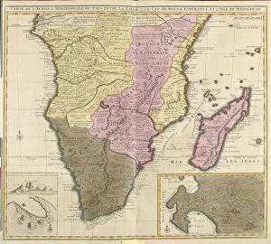
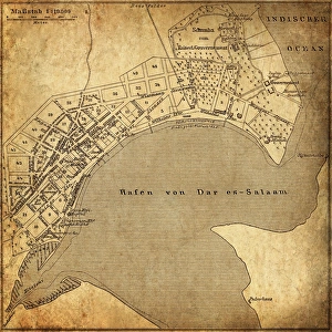
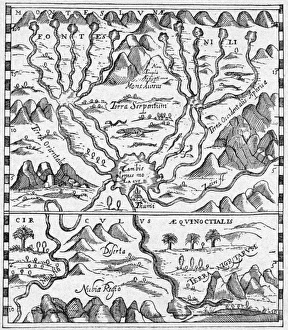
The Maps of Zambia Africa collection from Media Storehouse offers a unique and visually stunning way to explore the geography and history of this fascinating country. Our collection features a range of maps, from detailed topographical maps to antique hand-drawn maps that provide insight into the region's colonial past. Each map is expertly reproduced using high-quality printing techniques, ensuring that every detail is captured with precision and clarity. Whether you're looking for a striking piece of wall art or an educational resource for your classroom or office, the Maps of Zambia Africa collection has something to offer. From the winding course of the Zambezi River to the rugged terrain of Victoria Falls National Park, these maps showcase some of Zambia's most iconic landmarks and natural wonders. With its rich cultural heritage and diverse landscapes, Zambia is a country worth exploring in depth – and there's no better way to do so than with these beautiful maps from Media Storehouse.
+
What are Maps of Zambia Africa art prints?
Maps of Zambia Africa art prints are high-quality reproductions of maps that depict the geography and topography of Zambia, a landlocked country in southern Africa. These art prints showcase the intricate details of Zambia's diverse landscape, including its rivers, mountains, forests, and wildlife reserves. Maps of Zambia Africa art prints are not only aesthetically pleasing but also serve as educational tools for those interested in learning more about this beautiful country. They can be used to decorate homes or offices with an African theme or as gifts for friends and family who have a connection to Zambia. These art prints come in various sizes and formats such as canvas, framed print or poster. They are printed using advanced printing technology on high-quality paper to ensure they retain their vibrancy and clarity over time. Whether you're a collector of African-themed artwork or simply looking for unique wall decor that showcases your love for travel and exploration, Maps of Zambia Africa art prints offer something special that will enhance any space.
+
What Maps of Zambia Africa art prints can I buy from Media Storehouse?
We offer a wide range of Maps of Zambia Africa art prints that are perfect for those who love geography and history. These maps showcase the different regions, cities, and landmarks in Zambia, providing an excellent visual representation of the country's topography. Some popular options include antique maps that date back to the 19th century, as well as more modern designs that feature vibrant colors and detailed illustrations. You can choose from various sizes and formats such as canvas prints or framed prints to suit your preferences. Whether you're looking for a unique piece of wall art for your home or office or searching for a thoughtful gift idea for someone interested in African culture, we have something to offer. With their vast collection of Maps of Zambia Africa art prints available online, it's easy to find exactly what you're looking for.
+
How do I buy Maps of Zambia Africa art prints?
To buy Maps of Zambia Africa art prints from Media Storehouse, you can browse our extensive collection of artwork online. You can search for specific keywords or themes related to the type of map you are looking for, such as vintage maps or topographical maps. Once you have found a print that interests you, simply add it to your cart and proceed to checkout. During the checkout process, make sure to enter your shipping and billing information accurately. You will also be given the option to choose your preferred payment method. Once your order has been processed and shipped, you should receive a confirmation email with tracking information so that you can keep track of when your Maps of Zambia Africa art prints will arrive. Buying Maps of Zambia Africa art prints from Media Storehouse is a simple and straightforward process that allows you to easily add beautiful pieces of artwork to your home or office decor.
+
How much do Maps of Zambia Africa art prints cost?
We offer a wide range of Maps of Zambia Africa art prints at varying prices. Our collection includes vintage maps, satellite images and contemporary designs that showcase the beauty and diversity of this African country. The cost of our Maps of Zambia Africa art prints depends on various factors such as size, framing options and materials used. We have affordable options for those on a budget as well as high-quality premium prints for those looking to make a statement in their home or office decor. Our Maps of Zambia Africa art prints are printed using state-of-the-art printing technology to ensure vibrant colors and sharp details that will last for years to come. Whether you're looking for a gift or something to decorate your own space, we have something for everyone's taste and budget. Browse through our collection today to find the perfect Map of Zambia Africa art print that suits your style.
+
How will my Maps of Zambia Africa art prints be delivered to me?
Your Maps of Zambia Africa art prints will be delivered to you in a secure and timely manner. We take great care in packaging your order so that it arrives to you in pristine condition. Depending on the size of your print, it may be shipped flat or rolled up in a sturdy tube. Our shipping partners are reliable and experienced, ensuring that your package is handled with care throughout its journey. We understand how important it is for our customers to receive their orders promptly, which is why we strive to dispatch all orders as quickly as possible. You can expect regular updates on the status of your delivery, including tracking information once your order has been dispatched. We pride ourselves on providing high-quality products and exceptional customer service. If you have any questions or concerns about the delivery of your Maps of Zambia Africa art prints, please don't hesitate to contact us and we'll do everything we can to assist you.