Fraud Blocker Skip to main content

Home > Asia > Palestine > Maps

Maps Collection

Maps of Palestine Asia are maps that show the physical geography of the region

Choose a picture from our Maps Collection for your Wall Art and Photo Gifts

273 items

Background imageMaps Collection: Antique map of the Middle East by Halma

Antique map of the Middle East by Halma

Background imageMaps Collection: Map of the ancient Jerusalem, copperplate engraving, published in 1774

Map of the ancient Jerusalem, copperplate engraving, published in 1774
Map of the ancient Jerusalem. Copperplate engraving, published in 1774

Background imageMaps Collection: Map of ancient Palestine kingdoms of Judah and Israel

Map of ancient Palestine kingdoms of Judah and Israel
Map of Phoenicia and Judea in the time of King Solomon, 10th century BC. Hand-colored woodcut of a 19th-century illustration

Background imageMaps Collection: Palestine map 1875

Palestine map 1875
The Independent Course Comprehensive Geography by James Monteith, A.S. Barnes & Co, New York & Chicago 1875

Background imageMaps Collection: Oldest map of Palestine, mosaic, dated AD 560, St. Georges Church, Madaba, Jordan

Oldest map of Palestine, mosaic, dated AD 560, St. Georges Church, Madaba, Jordan, Middle East

Background imageMaps Collection: Map of Palestine and the Holy Land

Map of Palestine and the Holy Land - all places named in their Latin form. Date: 1806

Background imageMaps Collection: Map of Palestine, 1588

Map of Palestine, 1588
16th century map of Palestine. North is towards upper right. Published in 1588, this German map shows the geography of Palestine, centred on the area that later become the state of Israel

Background imageMaps Collection: Palestine map 1885

Palestine map 1885
Encyclopedia Britannica 9th Edition New York Charles Scribners and Sons 1885 Vol XVIII

Background imageMaps Collection: Madaba Mosaic Map, 6th century AD, detail showing Jerusalem, Madaba, Jordan

Madaba Mosaic Map, 6th century AD, detail showing Jerusalem, Madaba, Jordan, Middle East " The mosaic represents the biblical land from Egypt to Lebanon including Sinai, Israel

Background imageMaps Collection: Map of Palestine in the time of Jesus Christ

Map of Palestine in the time of Jesus Christ
Vintage engraving of Map of Palestine in the time of Jesus Christ

Background imageMaps Collection: Mideast map during the Crusades

Mideast map during the Crusades
Map of the Middle East at the time of the Crusades. Printed color lithograph

Background imageMaps Collection: Southern Palestine in ancient times

Southern Palestine in ancient times
Map of southern Palestine in ancient times. Printed color lithograph of a 19th-century illustration

Background imageMaps Collection: Map / Asia / Palestine / Bible

Map / Asia / Palestine / Bible
A map of Palestine during the period of Jesuss life there

Background imageMaps Collection: Antique Map - Biblical Palestine

Antique Map - Biblical Palestine
Antique Map from 1864 of Biblical Palestine

Background imageMaps Collection: Historical map of Palestine with the twelve tribes of Israel

Historical map of Palestine with the twelve tribes of Israel. Colored steel engraving, published in 1886

Background imageMaps Collection: Dynasties in the time of the Buwayids, circa 932 A. D. c1915. Creator: Emery Walker Ltd

Dynasties in the time of the Buwayids, circa 932 A. D. c1915. Creator: Emery Walker Ltd
Dynasties in the time of the Buwayids, circa 932 A.D. c1915. Map of civilisations in the Middle East during the 10th century: Byzantine, Buwayid Kingdom, Abbasid Caliphate, Kingdom of the Ikhshids

Background imageMaps Collection: Antique map of the Middle East with Egypt, Syria, and Israel

Antique map of the Middle East with Egypt, Syria, and Israel. Date unknown

Background imageMaps Collection: Modern Palestine 1851

Modern Palestine 1851
A fine facimile artworked from an antique original map of Modern Palestine, issued as part of the 1851 edition of John Tallis and Companys " The Illustrated Atlas

Background imageMaps Collection: Byzantine and Crusaders v. Seljuks, circa 1130 A. D. c1915. Creator: Emery Walker Ltd

Byzantine and Crusaders v. Seljuks, circa 1130 A. D. c1915. Creator: Emery Walker Ltd
Byzantine and Crusaders v. Seljuks, circa 1130 A.D. c1915. Map of civilisations in the Middle East during the 12th century: Byzantine, other Christian states, Abbasid Caliphate, Seljuks, Fatimids

Background imageMaps Collection: Panoramic view of Palestine with Jerusalem City, 1833. Artist: Anonymous

Panoramic view of Palestine with Jerusalem City, 1833. Artist: Anonymous
Panoramic view of Palestine with Jerusalem City, 1833. Found in the collection of the State History Museum, Moscow

Background imageMaps Collection: Antique map of holy land including Syria and Lebanon

Antique map of holy land including Syria and Lebanon

Background imageMaps Collection: Neri to Akra, c1915. Creator: Stanfords Geographical Establishment

Neri to Akra, c1915. Creator: Stanfords Geographical Establishment
Neri to Akra, c1915. Map showing the journey of British writer, soldier and diplomatic advisor Mark Sykes in Turkey, (at that time part of the Ottoman Empire)

Background imageMaps Collection: 1865, Spruner Map of Israel, Canaan, or Palestine in Ancient Times, topography, cartography

1865, Spruner Map of Israel, Canaan, or Palestine in Ancient Times, topography, cartography
1865, Spruner Map of Israel, Canaan, or Palestine in Ancient Times

A plan of Jerusalem dating back to the Crusaders
3507247 A plan of Jerusalem dating back to the Crusaders; (add.info.: A plan of Jerusalem dating back to the Crusaders. Dated 11th Century.); Universal History Archive

Palestine in the time of Christ (colour litho)
8630311 Palestine in the time of Christ (colour litho) by English School, (19th century); Private Collection; (add.info.: Palestine in the time of Christ)

Map showing the Roads from Jerusalem to Damascus (engraving)
8663084 Map showing the Roads from Jerusalem to Damascus (engraving) by English School, (19th century); Private Collection; (add.info.: Map showing the Roads from Jerusalem to Damascus)

Map of the kingdoms of Judah and Israel. From Cassell's Universal History, published 1888 (b/w engraving)
6867228 Map of the kingdoms of Judah and Israel. From Cassell's Universal History, published 1888 (b/w engraving); (add.info.: Map of the kingdoms of Judah and Israel)

Map of the Twelve Tribes of Israel, Canaan, or Palestine, as it was divided between the twelve tribes of Israel
6117853 Map of the Twelve Tribes of Israel, Canaan, or Palestine, as it was divided between the twelve tribes of Israel. After a map published in 1750 (map); Photo © Ken Welsh

Map of Phenicia and the Kingdom of Judee under King Solomon, 10th century BC (Old Testament)
NWI4856509 Map of Phenicia and the Kingdom of Judee under King Solomon, 10th century BC (Old Testament). The following territories are represented: Holy Land, Palestine, Gaza Strip, Lebanon, Syria

Geographic map of the Middle East at the time of the Crusades. Lithography, 19th century
NWI4876898 Geographic map of the Middle East at the time of the Crusades. Lithography, 19th century.; (add.info.: Geographic map of the Middle East at the time of the Crusades)

Palestine and Adjacent Countries, 1849
2902288 Palestine and Adjacent Countries, 1849; (add.info.: Palestine and Adjacent Countries, 1849.); Buyenlarge Archive/UIG

The Kingdoms of Judah and Israel, during the Monarchy (colour litho)
8630307 The Kingdoms of Judah and Israel, during the Monarchy (colour litho) by English School, (19th century); Private Collection; (add.info.: The Kingdoms of Judah and Israel, during the Monarchy)

Modern Palestine (colour litho)
8630315 Modern Palestine (colour litho) by English School, (19th century); Private Collection; (add.info.: Modern Palestine)

Palestine (colour litho)
8658804 Palestine (colour litho) by English School, (20th century); Private Collection; (add.info.: Palestine. Illustration for The London School Atlas edited by H O Arnold-Forster)

Map of Jerusalem and Palestine (Israel), circa 1870. 19th century lithography
NWI4878349 Map of Jerusalem and Palestine (Israel), circa 1870. 19th century lithography.; (add.info.: Map of Jerusalem and Palestine (Israel), circa 1870

Map of Palestine part of Turkey, c.1900 (engraving)
533323 Map of Palestine part of Turkey, c.1900 (engraving); (add.info.: Map of Palestine (then part of Turkey), circa 1902

Background imageMaps Collection: From Jerusalem to Bethany (engraving)

From Jerusalem to Bethany (engraving)
8663091 From Jerusalem to Bethany (engraving) by English School, (19th century); Private Collection; (add.info.: From Jerusalem to Bethany)

Background imageMaps Collection: Map of the Ottoman Empire (colour litho)

Map of the Ottoman Empire (colour litho)
8664038 Map of the Ottoman Empire (colour litho) by English School, (19th century); Private Collection; (add.info.: Map of the Ottoman Empire)

Background imageMaps Collection: Map of the kingdom of Herode I the Great at the birth of Jesus Christ including the kingdom of

Map of the kingdom of Herode I the Great at the birth of Jesus Christ including the kingdom of Judee, Samaria
ELD4921457 Map of the kingdom of Herode I the Great at the birth of Jesus Christ including the kingdom of Judee, Samaria, Galilee

Map of Palestine, engraving 1830
2604041 Map of Palestine, engraving 1830; (add.info.: Map of Palestine showing distances in Roman miles. Based on various ancient authors and the " Jerusalem Itinerary". Engraving c1830)

Background imageMaps Collection: Map of Palestine, circa 1800

Map of Palestine, circa 1800. From Gaza and Ashkelon in the south to Tyre and Sidon (Lebanon) in the north. La Palestina. Handcoloured copperplate engraving after Giulio Ferrario in his Costumes

Background imageMaps Collection: Ancient Palestine 1851

Ancient Palestine 1851
A fine facimile artworked from an antique original map of Ancient Palestine, issued as part of the 1851 edition of John Tallis and Companys " The Illustrated Atlas

Background imageMaps Collection: Antique map of Palestine, 1897, late 19th Century

Antique map of Palestine, 1897, late 19th Century
Vintage engraving of Antique map of Palestine, 1897, late 19th Century

Background imageMaps Collection: Map of Palestine 1900

Map of Palestine 1900
Meyers hand-Atlas Leipzig und Wien Verlag des Bibliographischen Instituts 1900

Background imageMaps Collection: The Holy Land (Palestine), 1720-1744 (engraving)

The Holy Land (Palestine), 1720-1744 (engraving)
1949284 The Holy Land (Palestine), 1720-1744 (engraving) by Seutter, Georg Matthaus (1678-1757); (add.info.: Map of Palestine, from "L'Atlas Minor" by Matthaeus Seutter, Augsbourg)

Background imageMaps Collection: Palestine Ai300

Palestine Ai300
Omar ELMOUDDEN

Background imageMaps Collection: Old Antique map of Palestine with detail of Jerusalem, 1890s, 19th Century

Old Antique map of Palestine with detail of Jerusalem, 1890s, 19th Century
Antique map of Palestine with detail of Jerusalem, 1890s, 19th Century

Background imageMaps Collection: Antique map of Ancient Palestine, with detail of Jerusalem, Atlas of Ancient Geography

Antique map of Ancient Palestine, with detail of Jerusalem, Atlas of Ancient Geography
Vintage illustration of Antique map of Ancient Palestine, with detail of Jerusalem, Atlas of Ancient Geography. By Samuel Butler


All Professionally Made to Order for Quick Shipping


-

Maps Collection

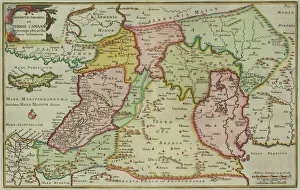
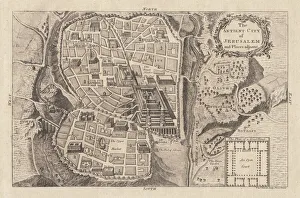
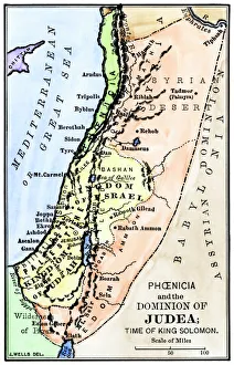
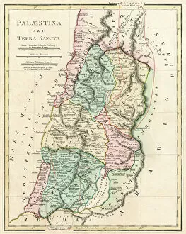
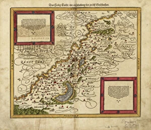
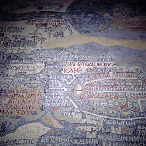
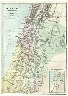
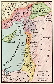
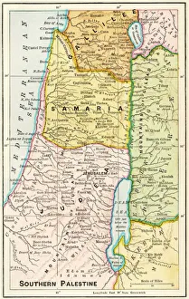
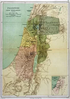
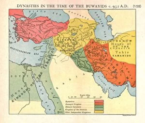
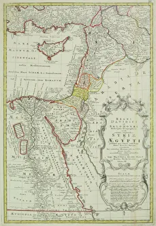
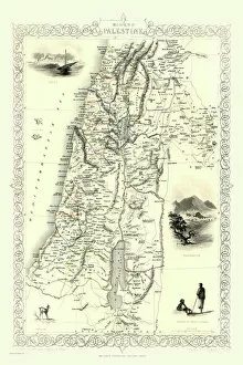
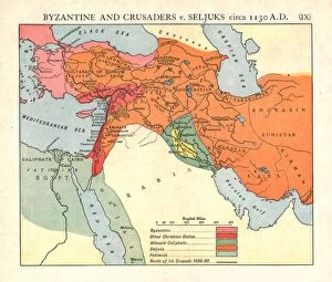
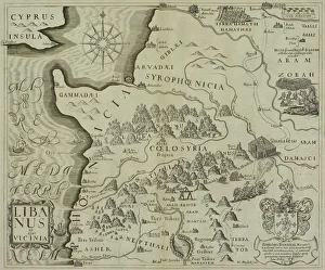
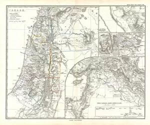
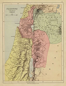
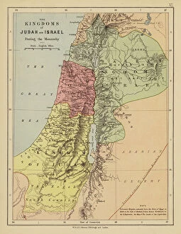
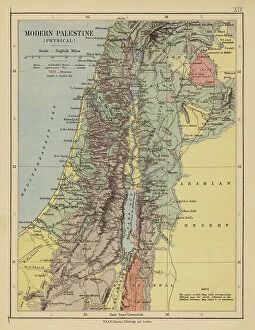
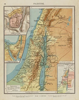
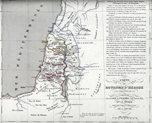
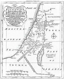
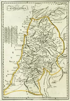
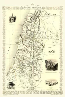
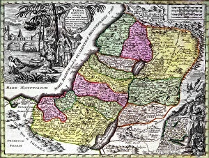
Maps of Palestine Asia are maps that show the physical geography of the region. They often include political boundaries, cities, rivers, mountains, and other geographical features. They may also include historical information such as ancient sites and archaeological finds. Maps of Palestine Asia can be used for a variety of purposes including travel planning, research projects, teaching materials, or simply to gain an understanding of the area’s geography and can available in various formats including digital versions which can be accessed online or through mobile applications. By studying these maps one can gain an appreciation for the rich history and culture that have shaped this region over time.
+

Our beautiful pictures are available as Framed Prints, Photos, Wall Art and Photo Gifts

The Maps of Palestine Asia collection from Media Storehouse is a stunning compilation of antique maps that depict the region of Palestine and its surrounding areas. Our collection includes a diverse range of maps, dating back to the 16th century, showcasing different styles and techniques used by cartographers throughout history. These maps offer an insight into how people perceived the geography and political boundaries of this area over time. They also provide valuable historical context for understanding the complex issues that have shaped this region in modern times. The Maps of Palestine Asia collection features high-quality reproductions that are perfect for wall art or framed prints. They make excellent gifts for history buffs or anyone interested in Middle Eastern culture and politics. Our collection is a fascinating glimpse into the past and offers a unique way to appreciate both the beauty and complexity of this important part of our world.
+

What are Maps of Palestine Asia art prints?

Maps of Palestine Asia art prints are high-quality reproductions of maps that depict the geographical region of Palestine in Asia. These prints are created using advanced printing techniques and materials to ensure that they capture every detail and color of the original map. These art prints are not only visually stunning but also serve as valuable historical documents, providing insight into the political and cultural landscape of this important region. They can be used for educational purposes or as decorative pieces in homes, offices, or public spaces. Maps of Palestine Asia art prints come in a variety of sizes and styles to suit different tastes and preferences. Some feature antique maps with intricate details while others showcase modern interpretations with bold colors and contemporary designs. Whether you're a history buff, an art lover, or simply looking for a unique piece to add to your collection, Maps of Palestine Asia art prints offer something special that is both beautiful and informative.
+

What Maps of Palestine Asia art prints can I buy from Media Storehouse?

We offer a wide range of Maps of Palestine Asia art prints that you can choose from. These maps are available in various sizes and styles, including vintage, antique, and contemporary designs. You can select a map that suits your taste and preferences to decorate your home or office space. Some of the popular Maps of Palestine Asia art prints available at Media Storehouse include detailed topographical maps, political maps showing borders and territories, historical maps depicting ancient civilizations and empires, as well as artistic renditions featuring intricate illustrations and calligraphy. Whether you're looking for a unique piece to add to your collection or want to gift someone special with an exquisite map print, we have got you covered. With their vast selection of high-quality Maps of Palestine Asia art prints sourced from renowned artists worldwide, you're sure to find something that catches your eye.
+

How do I buy Maps of Palestine Asia art prints?

To buy Maps of Palestine Asia art prints from Media Storehouse, you can browse our extensive collection of artwork online. Once you have found the print that you like, simply add it to your cart and proceed to checkout. You will be prompted to enter your shipping and payment information before completing your purchase. We offer a variety of sizes for their art prints, so make sure to select the size that best fits your needs. We also offer different framing options if you prefer a framed print. If you have any questions or concerns about purchasing Maps of Palestine Asia art prints from Media Storehouse, they have a customer service team available to assist you. You can contact them via email or phone for further assistance. Buying Maps of Palestine Asia art prints from Media Storehouse is an easy and convenient process that allows you to enjoy beautiful artwork in your home or office.
+

How much do Maps of Palestine Asia art prints cost?

We offer a wide range of Maps of Palestine Asia art prints for customers to choose from. The cost of these prints may vary depending on several factors such as the size, framing options and printing materials used. We have different sizes available that cater to various preferences and budgets. Our Maps of Palestine Asia art prints are made using high-quality printing techniques and materials to ensure that they are durable and long-lasting. We take pride in offering our customers with affordable yet premium quality art prints that can be enjoyed for years to come. We also provide customization options where you can select their preferred frame type or add additional features like matting or mounting. Our team is dedicated to providing excellent customer service, ensuring that all inquiries are promptly addressed. The cost of our Maps of Palestine Asia art prints is reasonable considering the quality and craftsmanship put into each piece.
+

How will my Maps of Palestine Asia art prints be delivered to me?

We take great care in ensuring that your Maps of Palestine Asia art prints are delivered to you safely and securely. We use high-quality packaging materials to protect your artwork during transit, including sturdy cardboard tubes for rolled prints and flat cardboard envelopes for smaller sizes. Once your order is processed, we will dispatch it promptly using our trusted delivery partners. Depending on the shipping option you choose at checkout, your Maps of Palestine Asia art prints may be delivered by standard mail or courier service. We understand how important it is to receive your artwork in pristine condition, which is why we offer a no-quibble returns policy if there are any issues with the quality of your print upon arrival. Rest assured that when you order from Media Storehouse, you can expect professional handling and delivery of your Maps of Palestine Asia art prints.