Home > Europe > United Kingdom > England > London > Sights > Tower of London
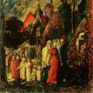
Tower of London and surrounding area 1597

![]()
Wall Art and Photo Gifts from Mary Evans Picture Library
Tower of London and surrounding area 1597
From a print published by the Royal Antiquarian Society and engraved from the survey made in 1597. Date: 1597
Mary Evans Picture Library makes available wonderful images created for people to enjoy over the centuries
Media ID 20158653
© Bubblepunk
1597 Antiquarian Area Draught Gascoyne Liberties Maps Plan Surrounding Boundries Gulielmus Smith
FEATURES IN THESE COLLECTIONS
> Architecture
> Towers
> Churches
> Architecture
> Towers
> Tower of London
> Europe
> United Kingdom
> England
> London
> River Thames
> Europe
> United Kingdom
> England
> London
> Royalty
> Europe
> United Kingdom
> England
> London
> Sights
> Tower of London
> Europe
> United Kingdom
> Heritage Sites
> Tower of London
> Maps and Charts
> Related Images
> Mary Evans Prints Online
> London
> Mary Evans Prints Online
> New Images July 2020
> Popular Themes
> Tower of London
> Religious Art
> Religious Architecture
> Churches and Cathedrals
EDITORS COMMENTS
This fascinating print, published by the Royal Antiquarian Society in 1597, offers a unique glimpse into the topography of London as it appeared over 400 years ago. The meticulously detailed map, engraved from a survey made in that year, centers around the iconic Tower of London, a historic fortress and palace located on the north bank of the River Thames. The Tower, which dates back to the late 11th century, is depicted in all its medieval grandeur, surrounded by its moat and connected to the mainland by a bridge. To the north, the print reveals the sprawling complex of the Royal Palace, which was the primary residence of the monarchy until the 17th century. The palace, which included the Chapel Royal, the White Tower, and the Bloody Tower, is shown with its various courtyards and gardens. To the east, the print reveals the bustling area of Barking Church and Hill, which was a popular residential and commercial district. The print also highlights the liberties of the Tower, including the precincts of the Tower Hill, the Tower Liberty, and the Water Lane Liberty. The surrounding area, which was dotted with churches, fields, and gardens, is also depicted in the print. Notable structures include St. Katharine's by the Tower, St. Mary Magdalen Bermondsey, and St. Mary Whitechapel. The River Thames, which played a crucial role in London's economic and social life, is shown winding its way through the city, with various wharves and docks indicated along its banks. This intricately detailed map, produced by the skilled hands of engravers Gulielmus Haiward, Gascoyne, East, Smith, and Field, provides a valuable record of London's topography during the 16th century. It offers a fascinating glimpse into the past, allowing us to visualize the city as it was over 400 years ago.
MADE IN AUSTRALIA
Safe Shipping with 30 Day Money Back Guarantee
FREE PERSONALISATION*
We are proud to offer a range of customisation features including Personalised Captions, Color Filters and Picture Zoom Tools
SECURE PAYMENTS
We happily accept a wide range of payment options so you can pay for the things you need in the way that is most convenient for you
* Options may vary by product and licensing agreement. Zoomed Pictures can be adjusted in the Cart.