Home > North America > Cuba > Maps
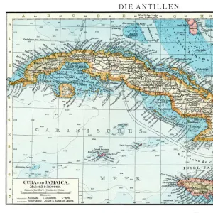
Map Of Cuba Circa. 1760. From "Atlas De Toutes Les Parties Connues Du Globe Terrestre "By Cartographer Rigobert Bonne. Published Geneva Circa. 1760

![]()
Wall Art and Photo Gifts from Design Pics
Map Of Cuba Circa. 1760. From "Atlas De Toutes Les Parties Connues Du Globe Terrestre "By Cartographer Rigobert Bonne. Published Geneva Circa. 1760
Map Of Cuba Circa. 1760. From " Atlas De Toutes Les Parties Connues Du Globe Terrestre " By Cartographer Rigobert Bonne. Published Geneva Circa. 1760
Design Pics offers Distinctively Different Imagery representing over 1,500 contributors
Media ID 18186380
© Ken Welsh / Design Pics
Cartography Cuba Geography Mapmaking Plate
FEATURES IN THESE COLLECTIONS
> Maps and Charts
> Related Images
> North America
> Cuba
> Maps
> North America
> Cuba
> Related Images
EDITORS COMMENTS
This print showcases a remarkable piece of history - the Map of Cuba circa 1760. Created by renowned cartographer Rigobert Bonne, this map is a true testament to his skill and precision in capturing the geographical details of the world. Published in Geneva around the same time, this particular map stands out for its vibrant colors and intricate engravings. The use of color brings life to each region, allowing viewers to visualize Cuba's diverse landscapes and natural features. The horizontal layout of the map allows for easy navigation, with clear labels indicating major cities, rivers, and mountain ranges. It serves as a valuable resource not only for historians but also for those interested in exploring Cuba's rich geography. The detailed illustration on this plate demonstrates Bonne's dedication to accuracy and his commitment to providing an informative depiction of Cuba during that era. Every stroke on this engraving tells a story about the island's past - from its colonial architecture to its bustling ports. Ken Welsh has expertly captured this historical gem through his lens, preserving it for generations to come. This print is more than just an image; it is a window into our collective past and an invitation to explore one of the most fascinating places on Earth - Cuba circa 1760.
MADE IN AUSTRALIA
Safe Shipping with 30 Day Money Back Guarantee
FREE PERSONALISATION*
We are proud to offer a range of customisation features including Personalised Captions, Color Filters and Picture Zoom Tools
SECURE PAYMENTS
We happily accept a wide range of payment options so you can pay for the things you need in the way that is most convenient for you
* Options may vary by product and licensing agreement. Zoomed Pictures can be adjusted in the Cart.