Home > Arts > Artists > H > Diego Homem
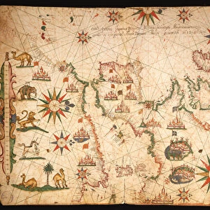
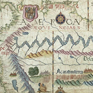
The British Isles, Iberia and Northwest Africa, detail from a world atlas, 1565 (vellum)
")
![]()
Wall Art and Photo Gifts from Fine Art Finder
The British Isles, Iberia and Northwest Africa, detail from a world atlas, 1565 (vellum)
XJL208769 The British Isles, Iberia and Northwest Africa, detail from a world atlas, 1565 (vellum) by Homem, Diego (16th century); The National Library of Russia, St. Petersburg, Russia; Portuguese, out of copyright
Media ID 12705307
© www.bridgemanart.com
Cartography Compass Del Mundo Diego Homm Iceland Portugues Mauritania
FEATURES IN THESE COLLECTIONS
> Africa
> Mauritania
> Maps
> Arts
> Artists
> H
> Diego Homem
> Europe
> Republic of Ireland
> Maps
> Fine Art Finder
> Artists
> Diego Homem
> Fine Art Finder
> Maps (celestial & Terrestrial)
The British Isles, Iberia and Northwest Africa - A Glimpse into the 16th Century World
EDITORS COMMENTS
. This print showcases a remarkable detail from a world atlas created in 1565 by Diego Homem, an esteemed Portuguese cartographer of the 16th century. The image depicts the British Isles, Iberia (modern-day Spain and Portugal), and Northwest Africa with astonishing precision on vellum. The intricate craftsmanship of this ancient map is truly awe-inspiring. Every contour of landmasses, every meandering coastline, and even minute details like rivers and mountain ranges are meticulously rendered. This masterpiece offers us a unique window into how these regions were perceived during that era. As we explore this historic artwork further, we can discern various fascinating elements. The British Isles reveal their distinctive shape, including Great Britain itself along with Ireland. Across the water lies mainland Europe encompassing France and Spain's vast territories. Moving southwards towards Africa's northwest coast, Mauritania emerges prominently on the map. Its geographical features are intricately depicted alongside other neighboring countries in North Africa. One cannot help but marvel at Homem's skillful use of cartographic techniques to create such an accurate representation of these lands centuries ago. This print serves as a testament to his mastery as well as our human fascination with exploration and understanding our place in the world. Displayed against a backdrop featuring compass roses indicating cardinal directions, this photograph captures not only historical significance but also artistic beauty that transcends time itself.
MADE IN AUSTRALIA
Safe Shipping with 30 Day Money Back Guarantee
FREE PERSONALISATION*
We are proud to offer a range of customisation features including Personalised Captions, Color Filters and Picture Zoom Tools
SECURE PAYMENTS
We happily accept a wide range of payment options so you can pay for the things you need in the way that is most convenient for you
* Options may vary by product and licensing agreement. Zoomed Pictures can be adjusted in the Cart.