Home > Arts > Artists > Related Images
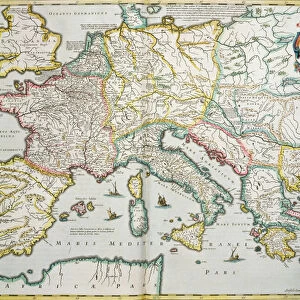
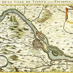
Map of the Roman Empire, c. 1675-76 (engraving)
")
![]()
Wall Art and Photo Gifts from Fine Art Finder
Map of the Roman Empire, c. 1675-76 (engraving)
986330 Map of the Roman Empire, c.1675-76 (engraving) by Sanson D Abbeville, Nicolas (1600-1667) (after); 61.5x45.5 (folio) cm; Private Collection; (add.info.: Map of the Roman Empire. Plate from Cartes Generales de la geographie encienne et nouvelle.... After Nicolas Sanson d Abbeville (1600-1667). Engraving. Published circa 1675-76. 61.5 x 45.5cm (folio).); Photo eChristies Images; French, out of copyright
Media ID 22638836
© Christie's Images / Bridgeman Images
1670s 1675 1676 Capital Letter Engraved Geographic Language Late 17th Century Late Seventeenth Century Latin Latin Text Navigational Equipment Plate Prints Artist French French Art French Artist
FEATURES IN THESE COLLECTIONS
> Arts
> Artists
> Related Images
> Europe
> Related Images
> Fine Art Finder
> Artists
> Edward Donovan
> Fine Art Finder
> Artists
> Nicolas (after) Sanson D'Abbeville
> Fine Art Finder
> Temp Classification
EDITORS COMMENTS
This print showcases a close-up view of the "Map of the Roman Empire" created by French artist Nicolas Sanson d'Abbeville in 1675-76. Measuring at an impressive 61.5x45.5cm, this engraving is a true masterpiece that offers a glimpse into the geographical landscape of ancient Rome. The map itself is intricately detailed, displaying various regions and cities within the vast Roman Empire. The Latin text accompanying the illustration adds an authentic touch to this historical artifact, allowing viewers to immerse themselves in the rich history and culture of this once-great civilization. Sanson d'Abbeville's skill as an illustrator shines through in every line and capital letter engraved on this plate. His meticulous attention to detail brings life to each geographic feature depicted on the map, making it not only informative but also visually stunning. As we delve into this late seventeenth-century artwork, we are reminded of how navigational equipment was crucial during that era for explorers and cartographers alike. This piece serves as both a testament to human curiosity about our world's past and an homage to European artists who dedicated their talents to preserving history through art. With no people present in the image, our focus remains solely on appreciating the craftsmanship behind this remarkable creation. This print from Fine Art Finder allows us to admire French artistry at its finest while offering insight into one of history's most influential empires - truly a treasure worth cherishing for generations to come.
MADE IN AUSTRALIA
Safe Shipping with 30 Day Money Back Guarantee
FREE PERSONALISATION*
We are proud to offer a range of customisation features including Personalised Captions, Color Filters and Picture Zoom Tools
SECURE PAYMENTS
We happily accept a wide range of payment options so you can pay for the things you need in the way that is most convenient for you
* Options may vary by product and licensing agreement. Zoomed Pictures can be adjusted in the Cart.