Home > Europe > United Kingdom > Northern Ireland > Posters
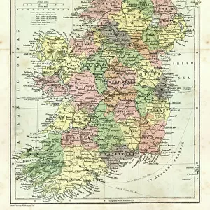
A Map of the Irish Free State & Northern Ireland, 1929 (colour litho)
")
![]()
Wall Art and Photo Gifts from Fine Art Finder
A Map of the Irish Free State & Northern Ireland, 1929 (colour litho)
1198397 A Map of the Irish Free State & Northern Ireland, 1929 (colour litho) by Gill, Leslie MacDonald (Max) (1884-1947); 102x153 cm; Private Collection; (add.info.: Gill, MacDonald (Max) (1884-1947)); Photo © Christies Images
Media ID 25188822
© Christie's Images / Bridgeman Images
1929 Armorial Capital Letter Cartography Classic Coats Of Arms Collectibles Collector Compass Crest Document Documentation Eire English Art English Artist English Text Fishing Industry Geographic Gill Green Colour Incopyright Information Label Land Language Large Group Large Group Of Objects Leslie Macdonald Gill Lettering List Lithographic Lithoprint Macdonald Gill Max Gill Navigational Equipment Northern Ireland Patterned Printed Prints Striped Stripes Stripey Water Transport Water Vehicle Water Vessel Word Artist British British Artist Irish Free State Natural Space To Fish
FEATURES IN THESE COLLECTIONS
> Animals
> Fishes
> G
> Grouper
> Animals
> Fishes
> Related Images
> Animals
> Mammals
> Muridae
> Water Mouse
> Arts
> Artists
> Related Images
> Europe
> France
> Canton
> Landes
> Europe
> Related Images
> Europe
> Republic of Ireland
> Maps
> Europe
> United Kingdom
> Maps
> Europe
> United Kingdom
> Northern Ireland
> Maps
> Europe
> United Kingdom
> Northern Ireland
> Posters
> Fine Art Finder
> Artists
> Leslie MacDonald (1884-1947) Gill
EDITORS COMMENTS
This print showcases "A Map of the Irish Free State & Northern Ireland, 1929" by Leslie MacDonald Gill, also known as Max Gill. The colorful lithograph measures an impressive 102x153 cm and is part of a private collection. The map itself is a stunning representation of early twentieth-century cartography, depicting the coastlines and land areas of both the Irish Free State and Northern Ireland. It features intricate details such as navigational equipment, crests, coats of arms, and labels indicating various points of interest. Max Gill's artistic talent shines through in this piece with his meticulous drawing skills and expert lettering. The vibrant green color dominates the map, symbolizing the lush landscapes found throughout Ireland. As we explore this close-up view, we can appreciate the artist's attention to detail in capturing every aspect of these regions' geography. From agricultural lands to bustling trade routes along the coastline, this map offers valuable information about both territories. The inclusion of ships on the water highlights their significance in facilitating commerce and transportation during that era. This nod to Ireland's fishing industry further emphasizes its economic importance at that time. Overall, this print provides us with a fascinating glimpse into British artist Max Gill's mastery in creating visually striking maps while offering insight into Ireland's rich history and natural beauty.
MADE IN AUSTRALIA
Safe Shipping with 30 Day Money Back Guarantee
FREE PERSONALISATION*
We are proud to offer a range of customisation features including Personalised Captions, Color Filters and Picture Zoom Tools
SECURE PAYMENTS
We happily accept a wide range of payment options so you can pay for the things you need in the way that is most convenient for you
* Options may vary by product and licensing agreement. Zoomed Pictures can be adjusted in the Cart.