Home > Europe > United Kingdom > England > London > Towns > Parsons Green
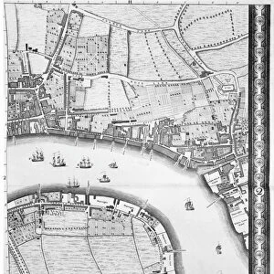
Map of Battersea & Chelsea, 1748 (engraving)
")
![]()
Wall Art and Photo Gifts from Fine Art Finder
Map of Battersea & Chelsea, 1748 (engraving)
XJF2639720 Map of Battersea & Chelsea, 1748 (engraving) by Rocque, John (c.1704-d.1762); Private Collection; (add.info.: Sheet 10 of An Exact View of the Citys of London, Westminster and the Borough of Southwark and the country near 10 miles round ); British, out of copyright
Media ID 12781522
© www.bridgemanimages.com
Battersea Cartography Chelsea Ferry Fields Stairs Survey Thames Worlds End Hans Sloane Parsons Green
FEATURES IN THESE COLLECTIONS
> Arts
> Artists
> R
> John Rocque
> Arts
> Landscape paintings
> Waterfall and river artworks
> River artworks
> Europe
> United Kingdom
> England
> London
> Boroughs
> City of Westminster
> Europe
> United Kingdom
> England
> London
> Boroughs
> Kensington and Chelsea
> Europe
> United Kingdom
> England
> London
> Boroughs
> Southwark
> Europe
> United Kingdom
> England
> London
> River Thames
> Europe
> United Kingdom
> England
> London
> Towns
> Battersea
> Europe
> United Kingdom
> England
> London
> Towns
> Chelsea
> Europe
> United Kingdom
> England
> London
> Towns
> Hither Green
> Europe
> United Kingdom
> England
> London
> Towns
> Parsons Green
> Fine Art Finder
> Artists
> John Rocque
EDITORS COMMENTS
This print showcases a remarkable piece of history, the "Map of Battersea & Chelsea, 1748". Engraved by John Rocque, this map provides a fascinating glimpse into London's past. As we delve into the intricacies of this engraving, we are transported back to a time when these areas were still rural landscapes. The map reveals the charming countryside that once enveloped Battersea and Chelsea, with vast fields stretching as far as the eye can see. It highlights significant landmarks such as Battersea Common Field and Chelsea Park, which have since evolved dramatically. The Thames River takes center stage in this depiction, serving as a vital lifeline for transportation and trade during that era. We catch glimpses of quaint stairs and ferry crossings along its banks – remnants of an era before modern bridges connected these neighborhoods. This engraving is part of "An Exact View of the Citys of London, Westminster and the Borough of Southwark" providing us with valuable insights into how these areas appeared over two centuries ago. With its meticulous cartography and attention to detail, it stands as a testament to Rocque's skillful craftsmanship. For history enthusiasts or those seeking to explore London's rich heritage from an entirely new perspective, this print offers an extraordinary opportunity to immerse oneself in Georgian-era charm.
MADE IN AUSTRALIA
Safe Shipping with 30 Day Money Back Guarantee
FREE PERSONALISATION*
We are proud to offer a range of customisation features including Personalised Captions, Color Filters and Picture Zoom Tools
SECURE PAYMENTS
We happily accept a wide range of payment options so you can pay for the things you need in the way that is most convenient for you
* Options may vary by product and licensing agreement. Zoomed Pictures can be adjusted in the Cart.