Home > North America > United States of America > New York > New York > Maps
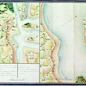
Map of Fisk-Kill and the position of the French army in 1782, from Guerre de

![]()
Wall Art and Photo Gifts from Fine Art Finder
Map of Fisk-Kill and the position of the French army in 1782, from Guerre de
XIR440780 Map of Fisk-Kill and the position of the French army in 1782, from Guerre de l Amerique, 1782 (colour engraving) by Dubourg, F. (fl.1780-82); Service Historique de la Marine, Vincennes, France; (add.info.: Plan de Fisk-Kill et position de l armee Francaise, en 1782 (colour engraving)); French, out of copyright
Media ID 12881893
© www.bridgemanimages.com
American War Of Independence French Army Hudson River New York State Revolutionary War Fishkill
FEATURES IN THESE COLLECTIONS
> Animals
> Fishes
> Related Images
> Fine Art Finder
> Artists
> F. Dubourg
> Maps and Charts
> Related Images
> North America
> United States of America
> Maps
> North America
> United States of America
> New York
> New York
> Maps
> North America
> United States of America
> New York
> Related Images
EDITORS COMMENTS
This color engraving titled "Map of Fisk-Kill and the position of the French army in 1782" takes us back to a pivotal moment in history during the American War of Independence. Created by F. Dubourg, this print provides an intricate plan of the town of Fishkill, New York State, and showcases the strategic positioning of the French army in 1782. The map offers a glimpse into the military tactics employed by both sides during this crucial period. The French army's presence is highlighted with precision, allowing viewers to visualize their influence on this particular region along the Hudson River Bay. As one examines this historical artifact, it becomes evident that Fishkill played a significant role as a base for operations during that time. Beyond its military significance, this print also serves as a testament to artistic craftsmanship. The vibrant colors and meticulous details bring life to each element depicted on the map. It is clear that Dubourg possessed great skill in capturing not only geographical accuracy but also conveying historical context through his engravings. Preserved at Service Historique de la Marine in Vincennes, France, this artwork stands as a valuable resource for historians and enthusiasts alike seeking to understand America's struggle for independence from British rule. By studying maps like these, we gain insight into how geography shaped warfare strategies and ultimately influenced major turning points throughout history.
MADE IN AUSTRALIA
Safe Shipping with 30 Day Money Back Guarantee
FREE PERSONALISATION*
We are proud to offer a range of customisation features including Personalised Captions, Color Filters and Picture Zoom Tools
SECURE PAYMENTS
We happily accept a wide range of payment options so you can pay for the things you need in the way that is most convenient for you
* Options may vary by product and licensing agreement. Zoomed Pictures can be adjusted in the Cart.