Home > Arts > Landscape paintings > Waterfall and river artworks > River artworks
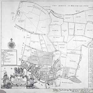
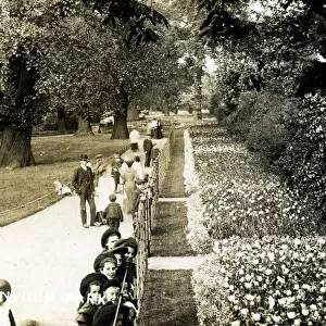
Map showing the Distribution of Deaths from Cholera in the Registration Districts of London

![]()
Wall Art and Photo Gifts from Fine Art Finder
Map showing the Distribution of Deaths from Cholera in the Registration Districts of London
XJF275636 Map showing the Distribution of Deaths from Cholera in the Registration Districts of London, 1866 (litho) (b/w photo) by English School, (19th century); Private Collection; (add.info.: The localized epidemic of Cholera killed 5, 596 people in the East End of London in 1866; ); English, out of copyright
Media ID 12791799
© www.bridgemanart.com
1849 1854 Bermondsey Bethnal Green Camberwell Chelsea Clerkenwell Contagious Disease Greenwich Hackney Holborn Islington Kensington Lambeth Lewisham Leyton Marylebone Mile End Newington Rotherhithe Sanitation Shoreditch Southwark St Giles St James St Martin In The Fields St Pancras Stepney Strand Stratford Thames Wandsworth West Ham Westminster Woolwich
FEATURES IN THESE COLLECTIONS
> Arts
> Landscape paintings
> Waterfall and river artworks
> River artworks
> Europe
> United Kingdom
> England
> London
> Boroughs
> City of Westminster
> Europe
> United Kingdom
> England
> London
> Boroughs
> Greenwich
> Europe
> United Kingdom
> England
> London
> Boroughs
> Hackney
> Europe
> United Kingdom
> England
> London
> Boroughs
> Islington
> Europe
> United Kingdom
> England
> London
> Boroughs
> Kensington and Chelsea
> Europe
> United Kingdom
> England
> London
> Boroughs
> Lambeth
> Europe
> United Kingdom
> England
> London
> Boroughs
> Lewisham
> Europe
> United Kingdom
> England
> London
> Boroughs
> Southwark
> Europe
> United Kingdom
> England
> London
> Boroughs
> Wandsworth
> Fine Art Finder
> Maps (celestial & Terrestrial)
> Fine Art Finder
> Schools
> English School
EDITORS COMMENTS
This haunting print titled "Map showing the Distribution of Deaths from Cholera in the Registration Districts of London, 1866" takes us back to a dark chapter in the city's history. Created by an anonymous English School artist in the 19th century, this map captures the devastating toll of a localized cholera epidemic that claimed the lives of 5,596 people in London's East End. The intricate details on this lithograph reveal how cholera spread across various districts including West Ham, Stratford, Leyton, Bethnal Green, Stepney, Mile End and many more. The names alone evoke a sense of grief and loss that permeated these communities during that time. As we study this map closely, it becomes clear that disease knows no boundaries. From Greenwich to Hackney and from Shoreditch to Westminster - every corner of London was affected by this contagious outbreak. The River Thames and Lea serve as somber reminders of how sanitation played a crucial role in containing or exacerbating such epidemics. Beyond its historical significance lies a powerful message about human vulnerability and resilience. This print serves as a stark reminder not only of past tragedies but also our collective responsibility to prioritize public health measures even today. Displayed proudly within private collections around the world, this artwork stands as both an educational tool and an artistic testament to those who lost their lives during one of London's darkest chapters.
MADE IN AUSTRALIA
Safe Shipping with 30 Day Money Back Guarantee
FREE PERSONALISATION*
We are proud to offer a range of customisation features including Personalised Captions, Color Filters and Picture Zoom Tools
FREE COLORIZATION SERVICE
You can choose advanced AI Colorization for this picture at no extra charge!
SECURE PAYMENTS
We happily accept a wide range of payment options so you can pay for the things you need in the way that is most convenient for you
* Options may vary by product and licensing agreement. Zoomed Pictures can be adjusted in the Cart.