Home > Africa > Libya > Maps
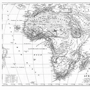
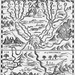
Map showing Egypt to Ethiopia, from the Ptolemy manuscript, c

![]()
Wall Art and Photo Gifts from Fine Art Finder
Map showing Egypt to Ethiopia, from the Ptolemy manuscript, c
XZL151832 Map showing Egypt to Ethiopia, from the Ptolemy manuscript, c.1470, illustration from Memoires de la Societe Royale de Geographie d Egypte (litho) by D Angiolo, Jacopo (fl.1470) (after); Private Collection; Italian, out of copyright
Media ID 12728380
© www.bridgemanart.com
FEATURES IN THESE COLLECTIONS
> Africa
> Ethiopia (Abyssinia)
> Related Images
> Africa
> Ethiopia
> Related Images
> Arts
> Artists
> Related Images
> Fine Art Finder
> Maps (celestial & Terrestrial)
> Maps and Charts
> Related Images
EDITORS COMMENTS
This print showcases a historic map that takes us back in time to the 15th century. The map, extracted from the Ptolemy manuscript dating back to around 1470, offers a fascinating glimpse into the geographical knowledge of that era. Spanning across Egypt and Ethiopia, this meticulously detailed illustration provides an invaluable insight into how these regions were perceived during the Renaissance period. The artist behind this masterpiece is Jacopo D'Angiolo, whose skillful lithography has beautifully brought this ancient cartographic gem to life. Preserved within a private collection, this artwork serves as a testament to the enduring allure of historical maps and their ability to transport us through time. As we explore this intricate chart, we are drawn towards key features such as Sudan's vast expanse and Libya's distinctive shape. The Nile River gracefully winds its way through both countries before reaching Egypt's fertile delta region. This visual representation not only highlights the importance of these waterways for trade and transportation but also sheds light on early perceptions of Africa's geography. With its inclusion of Middle Eastern territories, this map further emphasizes the interconnectedness between different regions during that period. It invites us to contemplate how knowledge was shared across borders and how exploration played a crucial role in shaping our understanding of the world. Through this remarkable photograph from Fine Art Finder by www. bridgemanart. com, we can appreciate both the artistic prowess involved in creating such maps and their significance in documenting historical perspectives on land boundaries and natural landmarks.
MADE IN AUSTRALIA
Safe Shipping with 30 Day Money Back Guarantee
FREE PERSONALISATION*
We are proud to offer a range of customisation features including Personalised Captions, Color Filters and Picture Zoom Tools
SECURE PAYMENTS
We happily accept a wide range of payment options so you can pay for the things you need in the way that is most convenient for you
* Options may vary by product and licensing agreement. Zoomed Pictures can be adjusted in the Cart.