Home > Animals > Mammals > Cricetidae > Miletus
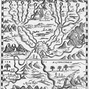
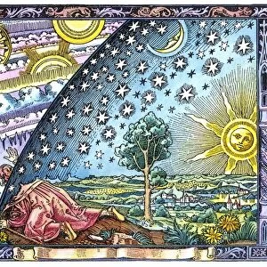
The world according to Hecataeus, published by John Murray (colour litho)
")
![]()
Wall Art and Photo Gifts from Fine Art Finder
The world according to Hecataeus, published by John Murray (colour litho)
XCF349757 The world according to Hecataeus, published by John Murray (colour litho) by English School, (19th century); Private Collection; (add.info.: Hecataeus of Miletus (c.550-c.490 BC) was a Greek geographer; ); English, out of copyright
Media ID 12863626
© www.bridgemanart.com
Cartography Continent Continents Mapping Mediterranean
FEATURES IN THESE COLLECTIONS
> Animals
> Mammals
> Cricetidae
> Miletus
> Asia
> Related Images
> Europe
> Greece
> Related Images
> Fine Art Finder
> Schools
> English School
> Historic
> Ancient civilizations
> Ancient Greece
> Greek history
> Maps and Charts
> Early Maps
> Maps and Charts
> Related Images
> Maps and Charts
> World
EDITORS COMMENTS
This vibrant and historically significant print showcases "The world according to Hecataeus" a map published by John Murray in the 19th century. The artwork, created by an English School artist, offers a fascinating glimpse into ancient cartography. Hecataeus of Miletus, a renowned Greek geographer from the 6th century BC, is credited with inspiring this intricate map. As we delve into its details, we are transported back in time to explore how people perceived the world centuries ago. The color lithograph beautifully brings out the nuances of this antique map. It depicts Europe, Asia, and the Mediterranean region with remarkable accuracy given the limited knowledge available during that era. Each continent is meticulously outlined and labeled, inviting us to embark on a visual journey through history. What makes this particular print even more captivating is its later coloration. This addition adds depth and vibrancy to an already mesmerizing piece of art. The colors breathe life into ancient lands and seas while simultaneously highlighting their cultural significance. As we gaze upon this extraordinary work of cartography, it serves as a reminder of humanity's ceaseless quest for knowledge about our planet's geography. It also pays homage to Hecataeus' pioneering efforts in mapping uncharted territories. This print not only appeals to enthusiasts of maps but also captivates those who appreciate historical artifacts brought back to life through modern technology.
MADE IN AUSTRALIA
Safe Shipping with 30 Day Money Back Guarantee
FREE PERSONALISATION*
We are proud to offer a range of customisation features including Personalised Captions, Color Filters and Picture Zoom Tools
SECURE PAYMENTS
We happily accept a wide range of payment options so you can pay for the things you need in the way that is most convenient for you
* Options may vary by product and licensing agreement. Zoomed Pictures can be adjusted in the Cart.