Home > Arts > Still life artwork > Watercolor paintings > Fine art
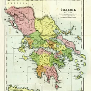
Illustrated map of Ancient Greece, BC

![]()
Wall Art and Photo Gifts from Fine Art Storehouse
Illustrated map of Ancient Greece, BC
Unleash your creativity and transform your space into a visual masterpiece!
Dorling Kindersley
Media ID 13540747
© This content is subject to copyright
Ancient Civilisations Ancient Greece Ancient History Background People Classical Greek Empire Geography Greece Illustrated Map Incidental People Watercolour Painting
FEATURES IN THESE COLLECTIONS
> Arts
> Still life artwork
> Watercolor paintings
> Fine art
> Fine Art Storehouse
> Photo Libraries
> Dorling Kindersley Prints
> Maps and Charts
> Early Maps
EDITORS COMMENTS
This stunning print captures the essence of Ancient Greece, taking us on a journey back in time to explore its rich history and captivating landscapes. Created by Dorling Kindersley, this illustrated map beautifully depicts the empire's physical geography with intricate details and vibrant watercolor painting. As we gaze upon this horizontal masterpiece, our eyes are immediately drawn to the ancient cities, temples, and landmarks that once stood proudly across Greece. The artist's skillful use of color brings life to each element, from the deep blues of the surrounding seas to the lush greens of olive groves and vineyards. Intriguingly cut out against a crisp white background, this studio shot allows us to focus solely on the magnificence of Ancient Greece without any distractions. The incidental people scattered throughout remind us that these were real civilizations thriving thousands of years ago. With every glance at this illustration, we can't help but marvel at how much has changed since those times while also appreciating how certain aspects have endured through centuries. It serves as a reminder of our connection to classical Greek culture and their significant contributions in areas such as philosophy, art, literature, and democracy. Whether you're an avid history enthusiast or simply captivated by beautiful artwork, this Illustrated Map of Ancient Greece is sure to transport you into a world long gone but forever etched in our collective memory.
MADE IN AUSTRALIA
Safe Shipping with 30 Day Money Back Guarantee
FREE PERSONALISATION*
We are proud to offer a range of customisation features including Personalised Captions, Color Filters and Picture Zoom Tools
SECURE PAYMENTS
We happily accept a wide range of payment options so you can pay for the things you need in the way that is most convenient for you
* Options may vary by product and licensing agreement. Zoomed Pictures can be adjusted in the Cart.