Home > Africa > Sudan > Maps
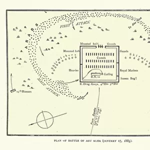
Map of the area arounf the Battle of Abu Klea, 1885

![]()
Wall Art and Photo Gifts from Fine Art Storehouse
Map of the area arounf the Battle of Abu Klea, 1885
Vintage illustration of Map of the area arounf the Battle of Abu Klea, 1885. The Battle of Abu Klea, or the Battle of Abu Tulayh took place between the dates of 16 and 18 January 1885, at Abu Klea, Sudan, between the British Desert Column and Mahdist forces encamped near Abu Klea
Unleash your creativity and transform your space into a visual masterpiece!
duncan1890
Media ID 21157917
© of Duncan P Walker
Mahdist Mahdist War Sudan Campaign Abu Klea
FEATURES IN THESE COLLECTIONS
> Fine Art Storehouse
> History
> Battles & Wars
> Historcal Battle Maps and Plans
> Maps and Charts
> Related Images
EDITORS COMMENTS
This vintage illustration captures the intricate details of a map depicting the area surrounding the historic Battle of Abu Klea in 1885. The battle, also known as the Battle of Abu Tulayh, unfolded between January 16th and 18th in Sudan. It pitted the British Desert Column against Mahdist forces who had established their camp near Abu Klea. The print showcases the strategic landscape where this significant clash took place during the larger context of the Mahdist War and Sudan Campaign. With meticulous precision, it highlights key geographical features that played a crucial role in shaping military tactics and outcomes. As we delve into this visual representation, we are transported back to an era when colonial powers vied for control over vast territories. The map serves as a testament to both historical events and cartographic artistry. Duncan1890's expertly preserved print allows us to appreciate not only its aesthetic value but also its educational significance. It offers viewers an opportunity to explore and understand how battles were fought on unfamiliar terrains, shedding light on strategies employed by both sides. Whether you are a history enthusiast or simply intrigued by maps from yesteryears, this remarkable piece is sure to captivate your imagination with its rich historical narrative woven into every contour line and symbol displayed on its surface.
MADE IN AUSTRALIA
Safe Shipping with 30 Day Money Back Guarantee
FREE PERSONALISATION*
We are proud to offer a range of customisation features including Personalised Captions, Color Filters and Picture Zoom Tools
SECURE PAYMENTS
We happily accept a wide range of payment options so you can pay for the things you need in the way that is most convenient for you
* Options may vary by product and licensing agreement. Zoomed Pictures can be adjusted in the Cart.