Home > Europe > Switzerland > St. Gallen
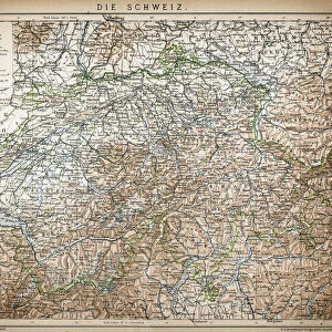
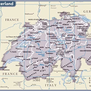
Antique Map of Switzerland

![]()
Wall Art and Photo Gifts from Fine Art Storehouse
Antique Map of Switzerland
Antique Map of Switzerland from 1898
Unleash your creativity and transform your space into a visual masterpiece!
Nastasic
Media ID 13668347
© Nikola Nastasic
1830 1839 78279 95839 Aging Process Appenzellerland Canton Bern Canton Central Europe Chart Condition European Alps Geneva Geneva Canton Geneva Switzerland Geographical Locations Graubunden Canton Image Created 1830 1839 Land Land Feature Lucerne Canton Navigational Equipment Pennine Alps St Gallen Canton Styles Swiss Alps Switzerland Ticino Canton Valais Canton Vaud Canton Zurich Canton Arolla Basel Fribourg Canton Guarda Image Created 19th Century Jungfrau Region Lugano Neuchatel Obsolete Pontresina Thurgau Uri Canton Victorian Style
FEATURES IN THESE COLLECTIONS
> Europe
> Switzerland
> Basel
> Europe
> Switzerland
> Bern
> Europe
> Switzerland
> Geneva
> Europe
> Switzerland
> Lucerne
> Europe
> Switzerland
> Lugano
> Europe
> Switzerland
> Maps
> Europe
> Switzerland
> St. Gallen
> Europe
> Switzerland
> Zurich
> Fine Art Storehouse
> The Magical World of Illustration
> Nastasic Images & Illustrations
> Fine Art Storehouse
> Map
> Historical Maps
> Maps and Charts
> Early Maps
> Maps and Charts
> Switzerland
EDITORS COMMENTS
This print showcases an exquisite "Antique Map of Switzerland" from 1898, taking us on a visual journey through the rich history and geographical marvels of this enchanting country. With intricate details and a Victorian-style aesthetic, this piece transports us back to the 19th century, offering a glimpse into the past. The map encompasses various Swiss regions such as Neuchatel, Pontresina, Thurgau, Lugano, Jungfrau Region, Uri Canton, Jura Canton, St Gallen Canton, Aargau Canton and many more. It beautifully captures the diverse landscapes of Switzerland - from the majestic Pennine Alps to the serene valleys of Graubunden Cantons. As we admire this aging masterpiece with its faded hues and delicate condition that bear witness to time's passage since it was created between 1830-1839; we are reminded of how maps were once essential navigational tools in an era before GPS technology. With its historical significance and artistic charm, this antique map serves as both a decorative piece for any space and a testament to Switzerland's enduring allure. Whether you're an avid cartography enthusiast or simply appreciate European heritage and natural beauty; let your imagination wander as you explore every inch of this remarkable artwork by Nastasic.
MADE IN AUSTRALIA
Safe Shipping with 30 Day Money Back Guarantee
FREE PERSONALISATION*
We are proud to offer a range of customisation features including Personalised Captions, Color Filters and Picture Zoom Tools
SECURE PAYMENTS
We happily accept a wide range of payment options so you can pay for the things you need in the way that is most convenient for you
* Options may vary by product and licensing agreement. Zoomed Pictures can be adjusted in the Cart.