Home > Europe > Italy > Lazio > Rome
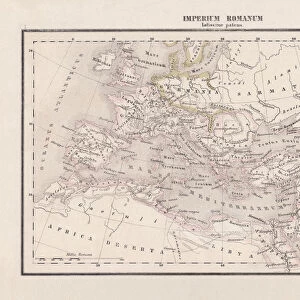
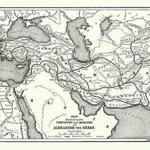
Roman empire under Trajan

![]()
Wall Art and Photo Gifts from Fine Art Storehouse
Roman empire under Trajan
Unleash your creativity and transform your space into a visual masterpiece!
Nastasic
Media ID 13593353
© Nikola Nastasic
Ancient History Ancient Rome Antiquities Biological Culture Chart Circa 1st Century Document Empire Ephemera European Culture Geographical Locations Greece Historical Document Iberian Peninsula Indigenous Culture Information Equipment Italian Culture Latin Script Macedonia Greece Mediterranean Countries Mediterranean Sea Navigational Equipment Orthographic Symbol Printed Media Roman Southern Europe Styles Temple Of Trajan Time Period Topography Classical Style Obsolete
FEATURES IN THESE COLLECTIONS
> Asia
> Related Images
> Europe
> Italy
> Lazio
> Rome
> Fine Art Storehouse
> The Magical World of Illustration
> Nastasic Images & Illustrations
> Fine Art Storehouse
> Map
> Historical Maps
> Fine Art Storehouse
> Map
> Italian Maps
> Maps and Charts
> Early Maps
> Maps and Charts
> Italy
> Maps and Charts
> North Macedonia
EDITORS COMMENTS
The captivating print titled "Roman Empire under Trajan" takes us on a visual journey through time, unraveling the rich tapestry of ancient history and civilization. This meticulously detailed cartographic illustration showcases the vast expanse of the Roman Empire during the reign of Emperor Trajan in the 1st century AD. With its focus on the Iberian Peninsula and Mediterranean countries, this antique document provides valuable insights into European culture and topography from that era. The Latin script and orthographic symbols add an authentic touch to this historical artifact, which serves as a window into indigenous cultures influenced by Roman rule. The classical style employed in this artwork transports us back to a bygone era when magnificent structures like the Temple of Trajan stood tall in Italy and Macedonia-Greece. As we explore geographical locations across Southern Europe, we are reminded of how interconnected these regions were through trade routes facilitated by navigational equipment depicted on this map. This printed media not only serves as an ephemeral piece but also acts as a treasure trove of information about biological cultures, capital cities, and even ancient civilizations beyond Europe's borders such as Asia. It is truly remarkable how one image can encapsulate centuries worth of history, inviting us to reflect upon our past while appreciating Italian culture and other diverse cultures that flourished under Roman influence. In summary, Nastasic's stunning print offers a glimpse into an obsolete yet awe-inspiring world - reminding us that our present is intricately woven with threads from our ancient roots
MADE IN AUSTRALIA
Safe Shipping with 30 Day Money Back Guarantee
FREE PERSONALISATION*
We are proud to offer a range of customisation features including Personalised Captions, Color Filters and Picture Zoom Tools
SECURE PAYMENTS
We happily accept a wide range of payment options so you can pay for the things you need in the way that is most convenient for you
* Options may vary by product and licensing agreement. Zoomed Pictures can be adjusted in the Cart.