Home > North America > United States of America > New York > New York > Maps
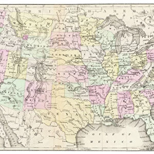
California Nevada map 1881

![]()
Wall Art and Photo Gifts from Fine Art Storehouse
California Nevada map 1881
Coltons Common School Geography 1881 New York Sheldon and Co
Unleash your creativity and transform your space into a visual masterpiece!
THEPALMER
Media ID 13669263
© This content is subject to copyright
American Culture California Globe Navigational Equipment Nevada North America Paper Planet Earth World Map
FEATURES IN THESE COLLECTIONS
> Fine Art Storehouse
> The Magical World of Illustration
> Palmer Illustrated Collection
> Fine Art Storehouse
> Map
> Historical Maps
> Fine Art Storehouse
> Map
> USA Maps
> Maps and Charts
> Early Maps
> Maps and Charts
> World
> North America
> United States of America
> California
> Related Images
> North America
> United States of America
> Maps
> North America
> United States of America
> Nevada
> Related Images
> North America
> United States of America
> New York
> New York
> Maps
EDITORS COMMENTS
This print showcases a remarkable piece of history, the "California Nevada map 1881" from Coltons Common School Geography. Published in New York by Sheldon and Co. , this engraving offers a glimpse into the past, capturing the essence of American culture and cartography during that era. The intricate details and precision of this old engraved image transport us back to a time when paper maps were essential navigational tools. The map itself is a testament to the artistry involved in creating such comprehensive illustrations. Every contour, river, and city is meticulously depicted on this antique piece, allowing us to explore the physical geography of California and Nevada as it was understood over a century ago. It serves as both an educational resource for students studying historical cartography and an aesthetic delight for those appreciating vintage artwork. Displayed vertically with utmost care by THEPALMER at Fine Art Storehouse, this print captures not only our attention but also our imagination. As we gaze upon it, we are reminded of how much our world has evolved since then while cherishing the timeless beauty that lies within these intricately crafted lines. Whether you're an avid collector or simply intrigued by history's visual representations, this stunning print transports you back in time through its enchanting portrayal of planet Earth's western region.
MADE IN AUSTRALIA
Safe Shipping with 30 Day Money Back Guarantee
FREE PERSONALISATION*
We are proud to offer a range of customisation features including Personalised Captions, Color Filters and Picture Zoom Tools
SECURE PAYMENTS
We happily accept a wide range of payment options so you can pay for the things you need in the way that is most convenient for you
* Options may vary by product and licensing agreement. Zoomed Pictures can be adjusted in the Cart.