Home > Europe > Austria > Maps
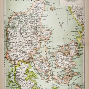
Central Europe map 1881

![]()
Wall Art and Photo Gifts from Fine Art Storehouse
Central Europe map 1881
Coltons Common School Geography 1881 New York Sheldon and Co
Unleash your creativity and transform your space into a visual masterpiece!
THEPALMER
Media ID 13669305
© This content is subject to copyright
Austria Denmark Globe Navigational Equipment Paper Planet Earth Switzerland World Map
FEATURES IN THESE COLLECTIONS
> Europe
> Switzerland
> Maps
> Fine Art Storehouse
> The Magical World of Illustration
> Palmer Illustrated Collection
> Fine Art Storehouse
> Map
> Denmark Maps
> Fine Art Storehouse
> Map
> Historical Maps
> Fine Art Storehouse
> Map
> Italian Maps
> Maps and Charts
> Early Maps
EDITORS COMMENTS
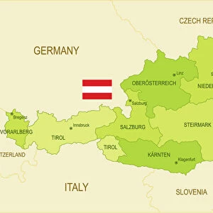
In this print titled "Central Europe map 1881" we are transported back in time to the late 19th century. The intricate details of this vintage map, sourced from Coltons Common School Geography published in New York by Sheldon and Co, provide a fascinating glimpse into the world as it was over a century ago. The horizontal composition allows us to explore Central Europe with ease, tracing our fingers along the delicate lines that delineate countries such as France, Denmark, Austria, Germany, Switzerland, and Italy. This beautifully engraved image showcases not only the artistry of cartography but also serves as a testament to the importance of physical geography during that era. As we examine this antique piece further, we notice various elements that add depth and character to its overall aesthetic. A globe navigational equipment sits atop the map - an emblematic symbol of exploration and discovery. The aged paper texture evokes nostalgia while reminding us of how far our understanding of planet Earth has come since then. "The Palmer" skillfully captures every nuance in this photograph print from Fine Art Storehouse. Through their lens, they have preserved history for us to marvel at today. Whether you are an enthusiast of old maps or simply appreciate fine art photography with historical significance, this exquisite artwork is sure to captivate your imagination and transport you back in time.
MADE IN AUSTRALIA
Safe Shipping with 30 Day Money Back Guarantee
FREE PERSONALISATION*
We are proud to offer a range of customisation features including Personalised Captions, Color Filters and Picture Zoom Tools
SECURE PAYMENTS
We happily accept a wide range of payment options so you can pay for the things you need in the way that is most convenient for you
* Options may vary by product and licensing agreement. Zoomed Pictures can be adjusted in the Cart.