Home > North America > United States of America > New York > New York > Maps
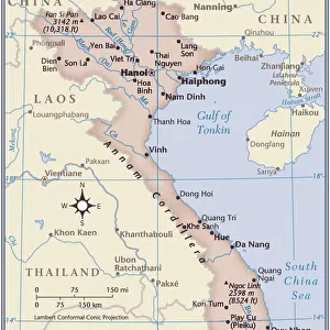
China and Japan map 1875

![]()
Wall Art and Photo Gifts from Fine Art Storehouse
China and Japan map 1875
The Independent Course Comprehensive Geography by James Monteith, A.S. Barnes & Co, New York & Chicago 1875
Unleash your creativity and transform your space into a visual masterpiece!
THEPALMER
Media ID 13612241
© This content is subject to copyright
China East Asia Globe Navigational Equipment India Indochina Japan Paper Vietnam China East Asia Drawing Art Product
FEATURES IN THESE COLLECTIONS
> Fine Art Storehouse
> The Magical World of Illustration
> Palmer Illustrated Collection
> Fine Art Storehouse
> Map
> Historical Maps
> Maps and Charts
> Early Maps
> Maps and Charts
> India
> Maps and Charts
> World
> North America
> United States of America
> Maps
> North America
> United States of America
> New York
> New York
> Maps
EDITORS COMMENTS
This print takes us back in time to the year 1875, when James Monteith's "China and Japan map" was published as part of his renowned work, "The Independent Course Comprehensive Geography". The intricate details of this vintage map transport us to a world where cartography was an art form. Displayed on aged paper, this antique engraving showcases the physical geography of East Asia with China and Japan at its center. It offers a glimpse into the historical boundaries of these nations, including India, Indochina, and Vietnam. The delicate etching captures not only the landmasses but also highlights their natural beauty. As we observe this piece closely, we can't help but appreciate the craftsmanship that went into creating such a detailed illustration. Every contour is meticulously engraved onto the surface with precision and care. This old-world charm evokes a sense of nostalgia for simpler times when maps were hand-drawn works of art. "The China and Japan map 1875" by THEPALMER serves as a reminder of how far our understanding of geography has come over the years. It stands as a testament to human curiosity about our planet's diverse landscapes and cultures. Whether you are an avid collector or simply fascinated by history, this stunning print will transport you back in time while igniting your imagination about distant lands waiting to be explored.
MADE IN AUSTRALIA
Safe Shipping with 30 Day Money Back Guarantee
FREE PERSONALISATION*
We are proud to offer a range of customisation features including Personalised Captions, Color Filters and Picture Zoom Tools
SECURE PAYMENTS
We happily accept a wide range of payment options so you can pay for the things you need in the way that is most convenient for you
* Options may vary by product and licensing agreement. Zoomed Pictures can be adjusted in the Cart.