Home > Europe > Austria > Maps
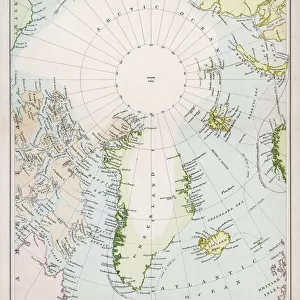
Comparative sizes map 1875

![]()
Wall Art and Photo Gifts from Fine Art Storehouse
Comparative sizes map 1875
The Independent Course Comprehensive Geography by James Monteith, A.S. Barnes & Co, New York & Chicago 1875
Unleash your creativity and transform your space into a visual masterpiece!
THEPALMER
Media ID 13612243
© This content is subject to copyright
Alabama Austria Florida Us State Globe Navigational Equipment Greece Gulf Coast States Iceland Paper Drawing Art Product
FEATURES IN THESE COLLECTIONS
> Fine Art Storehouse
> The Magical World of Illustration
> Palmer Illustrated Collection
> Fine Art Storehouse
> Map
> Historical Maps
> Maps and Charts
> Early Maps
> Maps and Charts
> World
> North America
> United States of America
> Alabama
> Related Images
> North America
> United States of America
> Florida
> Related Images
EDITORS COMMENTS
This print takes us back in time to the year 1875, when James Monteith's "Comparative sizes map" was published in his renowned book, "The Independent Course Comprehensive Geography". The print showcases an exquisite engraving that beautifully depicts a world map. As we gaze upon this historical artwork, our eyes are drawn to the intricate details and craftsmanship of the engraving. The lines etched onto the paper reveal a wealth of information about various countries and regions across the globe. From Iceland to Austria, Greece to the United States, including Florida and Alabama along with other Gulf Coast states - each place is meticulously represented. The antique charm emanating from this image transports us into an era where physical geography was explored through maps rather than digital screens. It serves as a reminder of how cartography played a vital role in understanding our planet's vastness. This print not only captures the essence of old-world elegance but also invites us to appreciate the artistry involved in creating such masterpieces. As we admire every stroke on this engraved image, it becomes evident that it is more than just a map; it is a work of art. "The Comparative Sizes Map 1875" by THEPALMER allows us to travel back in time and marvel at both its historical significance and artistic beauty.
MADE IN AUSTRALIA
Safe Shipping with 30 Day Money Back Guarantee
FREE PERSONALISATION*
We are proud to offer a range of customisation features including Personalised Captions, Color Filters and Picture Zoom Tools
SECURE PAYMENTS
We happily accept a wide range of payment options so you can pay for the things you need in the way that is most convenient for you
* Options may vary by product and licensing agreement. Zoomed Pictures can be adjusted in the Cart.