Home > North America > United States of America > New York > New York > Maps
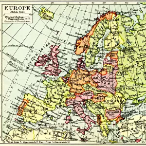
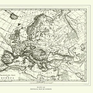
Europe relief map 1875

![]()
Wall Art and Photo Gifts from Fine Art Storehouse
Europe relief map 1875
The Independent Course Comprehensive Geography by James Monteith, A.S. Barnes & Co, New York & Chicago 1875
Unleash your creativity and transform your space into a visual masterpiece!
THEPALMER
Media ID 13612263
© This content is subject to copyright
Globe Navigational Equipment Paper Relief Relief Carving Relief Map Drawing Art Product
FEATURES IN THESE COLLECTIONS
> Europe
> Related Images
> Fine Art Storehouse
> The Magical World of Illustration
> Palmer Illustrated Collection
> Fine Art Storehouse
> Map
> Historical Maps
> Maps and Charts
> Early Maps
> Maps and Charts
> World
> North America
> United States of America
> Maps
> North America
> United States of America
> New York
> New York
> Maps
EDITORS COMMENTS
This print showcases an exquisite piece of history, the "Europe relief map 1875" from James Monteith's renowned book, "The Independent Course Comprehensive Geography". Published by A. S. Barnes & Co in New York and Chicago back in 1875, this remarkable engraving takes us on a journey through time to explore the physical geography of Europe. Crafted with meticulous detail, this antique map captures the essence of cartography at its finest. The intricate etching and illustration work bring to life the diverse landscapes that define Europe's natural beauty. From majestic mountain ranges to sprawling plains, every contour is delicately carved into paper. As we gaze upon this horizontal masterpiece, we are transported back to an era when globes were essential navigational tools. The artistry behind this relief carving is truly awe-inspiring; it serves as a testament to human ingenuity and curiosity about our world. The vintage charm exuded by this print adds a touch of nostalgia to any space it adorns. It invites us to reflect on how our understanding of geography has evolved over time while appreciating the timeless allure of old-world craftsmanship. "The Europe relief map 1875" by THEPALMER offers more than just a glimpse into historical cartography – it presents an opportunity for us to connect with nature's wonders and appreciate the artistic mastery that went into creating such enduring pieces.
MADE IN AUSTRALIA
Safe Shipping with 30 Day Money Back Guarantee
FREE PERSONALISATION*
We are proud to offer a range of customisation features including Personalised Captions, Color Filters and Picture Zoom Tools
SECURE PAYMENTS
We happily accept a wide range of payment options so you can pay for the things you need in the way that is most convenient for you
* Options may vary by product and licensing agreement. Zoomed Pictures can be adjusted in the Cart.