Home
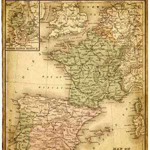
France Spain Portugal map 1856
Fine Art Storehouse Photo Prints and Wall Art
France Spain Portugal map 1856
Colton and Fitchs Modern School Geography by George W. Fitch - New York 1856. Unleash your creativity and transform your space into a visual masterpiece. © Roberto A Sanchez
THEPALMER
Media ID 13668739
European Union Mediterranean Sea Portugal Western Europe Retro Styled
FEATURES IN THESE COLLECTIONS
> Animals > Mammals > Muridae > Western Mediterranean Mouse
> Animals > Mammals > Muridae > Western Mouse
> Arts > Artists > P > Portuguese School
> Arts > Artists > S > Spanish School
> Europe > Portugal > Related Images
SECURE PAYMENTS
We happily accept a wide range of payment options so you can pay for the things you need in the way that is most convenient for you
MADE IN AUSTRALIA
Safe Shipping with 30 Day Money Back Guarantee
FREE PERSONALISATION
We are proud to offer a range of customisation including Cropping, Captions, and Filters. Zoom Cropping can be adjusted in the Basket.
EDITORS COMMENTS
This print takes us back in time to the year 1856, when cartography was a meticulous art form. The map showcased here is titled "France Spain Portugal map 1856" and it originates from the renowned book "Colton and Fitch's Modern School Geography" by George W. Fitch, published in New York during that era. The retro styling of this antique piece transports us to an era long gone, where physical geography played a crucial role in understanding the world. The intricate details of France, Spain, and Portugal are beautifully illustrated on this vertical map, capturing the essence of Western Europe. As we gaze upon this historical artifact, our eyes wander across the borders of these three countries nestled along the Mediterranean Sea. It serves as a reminder of their rich cultural heritage and interconnected histories within Europe. "The Palmer" who has brought forth this remarkable print through Fine Art Storehouse, allows us to appreciate not only its aesthetic value but also its educational significance. This artwork invites us to explore an age-old representation of geographical boundaries while igniting curiosity about how these nations have evolved over time. Whether you are an enthusiast for vintage maps or simply captivated by European history, this stunning illustration offers a unique glimpse into the past that will surely enrich any space it adorns.
Framed Prints
Introducing the exquisite "France Spain Portugal map 1856" framed print from our Media Storehouse collection. This stunning piece of historical cartography is a reproduction of a map from Colton and Fitch's Modern School Geography by George W. Fitch, published in New York in 1856. The intricate detailing and vibrant colors of the original map are beautifully preserved in this framed print, transporting you back in time to an era of exploration and discovery. Add an air of sophistication and historical charm to any room in your home or office with this unique and captivating framed print. Perfect for history enthusiasts, cartography collectors, or anyone who appreciates the beauty of vintage maps.
Photo Prints
Introducing the exquisite "France Spain Portugal map 1856" print from our Media Storehouse Fine Art Collection. This stunning antique map, created by THEPALMER for Colton and Fitch's Modern School Geography published in New York in 1856, offers a captivating glimpse into the historical cartography of Europe. With intricate detail and vibrant colors, this vintage map beautifully illustrates the political boundaries of France, Spain, and Portugal during that era. Perfectly suited for history enthusiasts, educators, and collectors, this museum-quality print is a must-have addition to any home or office. Immerse yourself in the rich history of Europe and add a touch of antiquity to your décor with the "France Spain Portugal map 1856" from Fine Art Storehouse.
Poster Prints
Introducing the captivating France Spain Portugal map print from ThePalmer's "Colton and Fitch's Modern School Geography" published in New York in 1856, now available as a stunning poster print from Media Storehouse's Fine Art Storehouse collection. This vintage map offers a fascinating glimpse into the geography of Europe during the mid-19th century, featuring detailed depictions of France, Spain, and Portugal. The intricate cartography, combined with the antique aesthetic, makes this poster print an excellent addition to any home or office space, transporting you back in time. Bring history to life with this exquisite and authentic reproduction.
Jigsaw Puzzles
Discover the rich history of European cartography with our exquisite France Spain Portugal map jigsaw puzzle from ThePalmer at Media Storehouse. Hailing from Colton and Fitch's "Modern School Geography" published in New York, 1856, this puzzle presents an intriguing glimpse into the geography of Europe during that era. Assemble the intricately cut pieces to reveal the detailed and vibrant map depicting the borders, territories, and landmarks of France, Spain, and Portugal in the mid-19th century. A perfect addition to any home or classroom, this jigsaw puzzle is not only an enjoyable pastime but also an educational tool that fosters a deeper understanding of historical geography. Immerse yourself in the past and create a captivating display with this beautiful and captivating puzzle.
Made With High Grade Materials
Professional Quality Finish
Carefully Packed To Aid Safe Arrival