Home > North America > United States of America > New York > New York > Maps
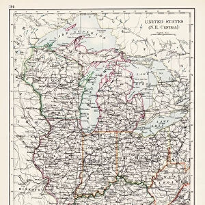
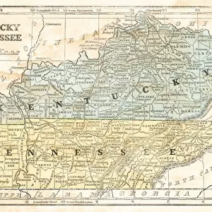
indiana Ohio Kentucky map 1881

![]()
Wall Art and Photo Gifts from Fine Art Storehouse
indiana Ohio Kentucky map 1881
Coltons Common School Geography 1881 New York Sheldon and Co
Unleash your creativity and transform your space into a visual masterpiece!
THEPALMER
Media ID 13669257
© This content is subject to copyright
American Culture Globe Navigational Equipment Indiana Kentucky North America Ohio Paper Planet Earth Tennessee World Map
FEATURES IN THESE COLLECTIONS
> Fine Art Storehouse
> The Magical World of Illustration
> Palmer Illustrated Collection
> Fine Art Storehouse
> Map
> Historical Maps
> Fine Art Storehouse
> Map
> USA Maps
> Maps and Charts
> Early Maps
> Maps and Charts
> World
> North America
> United States of America
> Indiana
> Related Images
> North America
> United States of America
> Kentucky
> Related Images
> North America
> United States of America
> Maps
> North America
> United States of America
> New York
> New York
> Maps
> North America
> United States of America
> Ohio
> Related Images
> North America
> United States of America
> Tennessee
> Related Images
EDITORS COMMENTS
In this print titled "Indiana Ohio Kentucky Map 1881" we are transported back in time to the late 19th century. The image showcases a beautifully detailed map from Coltons Common School Geography, published by Sheldon and Co in New York. This antique piece of cartography offers us a glimpse into the past, where paper maps were essential tools for navigation and education. The engraving is meticulously crafted, displaying the intricate borders of Indiana, Ohio, Kentucky, and Tennessee. It serves as a reminder of how these states were interconnected during that era. The illustration also includes other elements such as globe navigational equipment and a world map in the background, highlighting America's place within global geography. This photograph evokes nostalgia for an era when physical maps held great significance in American culture. It invites us to appreciate the artistry involved in creating such engravings while reflecting on our modern reliance on digital mapping technology. "The Palmer" has skillfully captured this historical artifact with precision and attention to detail. Through their lens, we can admire not only the craftsmanship of this engraved image but also gain insight into our planet Earth's physical geography as understood over a century ago. With its rich history and cultural significance, this print would make an excellent addition to any collection or serve as a thought-provoking conversation starter within your home or office space.
MADE IN AUSTRALIA
Safe Shipping with 30 Day Money Back Guarantee
FREE PERSONALISATION*
We are proud to offer a range of customisation features including Personalised Captions, Color Filters and Picture Zoom Tools
SECURE PAYMENTS
We happily accept a wide range of payment options so you can pay for the things you need in the way that is most convenient for you
* Options may vary by product and licensing agreement. Zoomed Pictures can be adjusted in the Cart.