Home > North America > United States of America > New York > New York > Maps
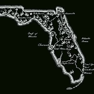
Map of Florida 1855

![]()
Wall Art and Photo Gifts from Fine Art Storehouse
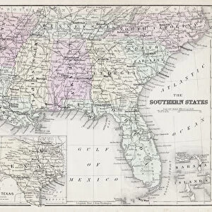
Map of Florida 1855
System of Geography for the use of schools by Sidney E. Morse - Published by Harper & Brothers - New York 1855
Unleash your creativity and transform your space into a visual masterpiece!
THEPALMER
Media ID 13668805
© Roberto A Sanchez
Alabama Atlantic Ocean Backgrounds Bay Of Water Dirty East Florida Us State Florida Usa Georgia Us State Gulf Coast States Paper Patina Scale Sepia Toned South Stained Textured Effect Obsolete Retro Styled
FEATURES IN THESE COLLECTIONS
> Fine Art Storehouse
> The Magical World of Illustration
> Palmer Illustrated Collection
> Fine Art Storehouse
> Map
> Historical Maps
> Fine Art Storehouse
> Map
> USA Maps
> Maps and Charts
> Early Maps
> Maps and Charts
> World
> North America
> United States of America
> Alabama
> Related Images
> North America
> United States of America
> Florida
> Related Images
> North America
> United States of America
> Georgia
> Related Images
> North America
> United States of America
> Maps
> North America
> United States of America
> New York
> New York
> Maps
EDITORS COMMENTS
This print takes us back in time to the year 1855, when a map of Florida was meticulously engraved by Sidney E. Morse for educational purposes. The retro styling and textured effect give this image an authentic vintage feel, transporting us to a bygone era. The map itself is a true testament to the artistry and precision of engraving techniques from that period. Its stained and dirty appearance adds character, revealing its age and history. With sepia tones enhancing the nostalgic atmosphere, we can almost imagine ourselves exploring the vast landscapes depicted on this aged piece of paper. Florida's eastern coastline stretches along the Atlantic Ocean, while its southern region borders Georgia and Alabama. The intricate details showcase various geographical features such as bays of water and even parts of the Gulf Coast states. As we examine this illustration closely, it becomes evident that it has stood the test of time with grace. The patina acquired over years only enhances its charm further. THEPALMER has captured not just a simple map but also a glimpse into history through this remarkable photo print. It serves as a reminder of how far cartography has come since then while appreciating the beauty found within these obsolete yet enduring engravings.
MADE IN AUSTRALIA
Safe Shipping with 30 Day Money Back Guarantee
FREE PERSONALISATION*
We are proud to offer a range of customisation features including Personalised Captions, Color Filters and Picture Zoom Tools
SECURE PAYMENTS
We happily accept a wide range of payment options so you can pay for the things you need in the way that is most convenient for you
* Options may vary by product and licensing agreement. Zoomed Pictures can be adjusted in the Cart.