Home > Europe > France > Canton > Maine
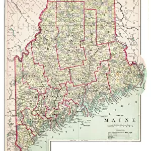
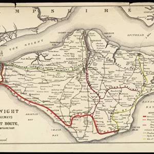
Map of Maine and Vermont1883

![]()
Wall Art and Photo Gifts from Fine Art Storehouse
Map of Maine and Vermont1883
Warrens Common School Geography
Unleash your creativity and transform your space into a visual masterpiece!
THEPALMER
Media ID 13669381
© This content is subject to copyright
Connecticut Maine Massachusetts New England Usa New Hampshire North America Paper Rhode Island Vermont
FEATURES IN THESE COLLECTIONS
> Europe
> France
> Canton
> Maine
> Europe
> United Kingdom
> England
> Hampshire
> Related Images
> Europe
> United Kingdom
> England
> Maps
> Fine Art Storehouse
> The Magical World of Illustration
> Palmer Illustrated Collection
> Fine Art Storehouse
> Map
> Historical Maps
> Fine Art Storehouse
> Map
> USA Maps
> Maps and Charts
> Early Maps
> Maps and Charts
> World
> North America
> United States of America
> Connecticut
> Related Images
> North America
> United States of America
> Maine
> Related Images
> North America
> United States of America
> Maps
> North America
> United States of America
> Massachusetts
> Related Images
EDITORS COMMENTS
This print of the "Map of Maine and Vermont 1883" takes us on a journey back in time to explore the intricate details of North America's New England region. The map, originally featured in Warrens Common School Geography, showcases an exquisite engraving that exudes both historical significance and artistic beauty. As we gaze upon this vintage masterpiece, our eyes are immediately drawn to the rich colors and delicate lines that bring life to each state depicted. From Massachusetts to Rhode Island, Vermont to Connecticut, every contour is meticulously etched onto aged paper, revealing a snapshot of physical geography from over a century ago. The enchanting allure lies not only in its cartographic accuracy but also in its ability to transport us into an era long gone. This engraved image serves as a testament to the artistry and craftsmanship prevalent during those times when maps were hand-drawn with utmost precision. "The Map of Maine and Vermont 1883" by THEPALMER captures our imagination with its antique charm. It invites us to delve deeper into history, exploring how these states have evolved since their depiction on this very map. Whether hung on display or studied closely for educational purposes, this print offers an opportunity for reflection on the ever-changing landscapes that shape our world today.
MADE IN AUSTRALIA
Safe Shipping with 30 Day Money Back Guarantee
FREE PERSONALISATION*
We are proud to offer a range of customisation features including Personalised Captions, Color Filters and Picture Zoom Tools
SECURE PAYMENTS
We happily accept a wide range of payment options so you can pay for the things you need in the way that is most convenient for you
* Options may vary by product and licensing agreement. Zoomed Pictures can be adjusted in the Cart.