Home > Europe > Montenegro > Maps
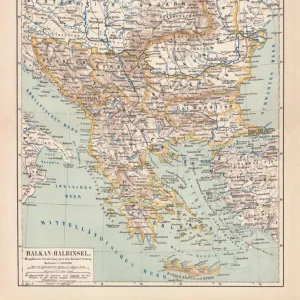
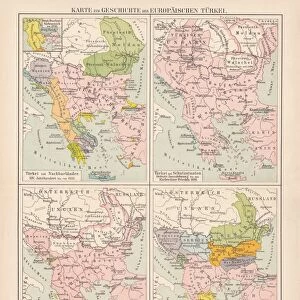
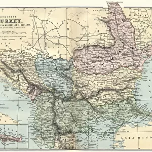
Map of Rumania Bulgaria 1896

![]()
Wall Art and Photo Gifts from Fine Art Storehouse
Map of Rumania Bulgaria 1896
Map of Rumania, Bulgaria, Serbia, Montenegro
Unleash your creativity and transform your space into a visual masterpiece!
THEPALMER
Media ID 13613591
© Roberto A Sanchez
62990 Bulgaria Dictionary Earth Globe Navigational Equipment Montenegro Romania Russia Serbia Retro Styled
FEATURES IN THESE COLLECTIONS
> Europe
> Montenegro
> Maps
> Fine Art Storehouse
> The Magical World of Illustration
> Palmer Illustrated Collection
> Fine Art Storehouse
> Map
> Historical Maps
> Maps and Charts
> Early Maps
> Maps and Charts
> Montenegro
EDITORS COMMENTS
This print takes us back in time to the year 1896, showcasing a meticulously detailed "Map of Rumania Bulgaria". The retro-styled image is an antique engraving that exudes a sense of history and sophistication. It beautifully captures the physical geography of this region, encompassing Romania, Bulgaria, Serbia, and Montenegro. The craftsmanship evident in this engraved map is truly remarkable. Every contour and boundary line has been intricately etched onto the surface with precision and care. As we gaze upon it, we are transported to an era when cartography was both an art form and a scientific endeavor. The old-world charm emanating from this piece is further enhanced by its horizontal composition. With no people present within the frame, our attention is solely focused on the intricate details of this historical map. Its significance lies not only in its aesthetic appeal but also as a valuable resource for understanding Europe's geopolitical landscape during that period. "The Map of Rumania Bulgaria 1896" serves as a visual dictionary that helps us navigate through time while exploring these countries' rich histories. This photograph print by THEPALMER offers us a glimpse into the past without commercial intentions or any mention thereof - simply allowing us to appreciate it as part of our collective heritage. Intriguingly captured in 2015 using photography techniques that highlight every minute detail, this artwork from Fine Art Storehouse brings together nostalgia and curiosity for those who seek to unravel the stories embedded within these ancient lands.
MADE IN AUSTRALIA
Safe Shipping with 30 Day Money Back Guarantee
FREE PERSONALISATION*
We are proud to offer a range of customisation features including Personalised Captions, Color Filters and Picture Zoom Tools
SECURE PAYMENTS
We happily accept a wide range of payment options so you can pay for the things you need in the way that is most convenient for you
* Options may vary by product and licensing agreement. Zoomed Pictures can be adjusted in the Cart.