Home > Europe > France > Canton > Maine
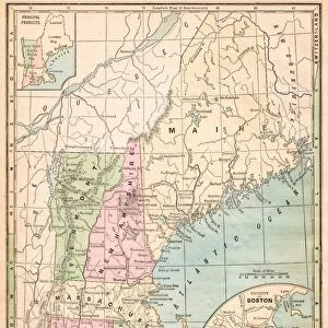
New England States USA map 1881

![]()
Wall Art and Photo Gifts from Fine Art Storehouse
New England States USA map 1881
Coltons Common School Geography 1881 New York Sheldon and Co
Unleash your creativity and transform your space into a visual masterpiece!
THEPALMER
Media ID 13669275
© This content is subject to copyright
American Culture Connecticut Globe Navigational Equipment Maine Massachusetts New Hampshire North America Paper Planet Earth Rhode Island Vermont World Map
FEATURES IN THESE COLLECTIONS
> Europe
> France
> Canton
> Maine
> Europe
> United Kingdom
> England
> Hampshire
> Related Images
> Europe
> United Kingdom
> England
> Maps
> Europe
> United Kingdom
> England
> York
> Fine Art Storehouse
> The Magical World of Illustration
> Palmer Illustrated Collection
> Fine Art Storehouse
> Map
> Historical Maps
> Fine Art Storehouse
> Map
> USA Maps
> Maps and Charts
> Early Maps
> Maps and Charts
> World
> North America
> United States of America
> Connecticut
> Related Images
> North America
> United States of America
> Maine
> Related Images
> North America
> United States of America
> Maps
EDITORS COMMENTS
This print of the "New England States USA map 1881" takes us on a journey back in time to explore the rich history and geography of this region. The intricate details and elegant engravings showcase the artistry involved in cartography during that era. The map, originally featured in Coltons Common School Geography 1881, offers a glimpse into how New England appeared over a century ago. It highlights states such as Massachusetts, Maine, New Hampshire, Connecticut, Rhode Island, and Vermont with precision and accuracy. Each state is meticulously labeled along with major cities and geographical features. The engraving also includes fascinating elements like globe navigational equipment symbolizing exploration and discovery. This serves as a reminder of America's deep connection to maritime trade routes during that period. As we admire this antique piece of paper illustration, it evokes feelings of nostalgia for an era long gone by. It reminds us of the importance placed on physical geography at that time when maps were essential tools for education and navigation. "The New England States USA map 1881" not only showcases American culture but also represents the evolution of cartography throughout history. Its presence adds a touch of vintage charm to any space while serving as a testament to our ever-changing planet Earth.
MADE IN AUSTRALIA
Safe Shipping with 30 Day Money Back Guarantee
FREE PERSONALISATION*
We are proud to offer a range of customisation features including Personalised Captions, Color Filters and Picture Zoom Tools
SECURE PAYMENTS
We happily accept a wide range of payment options so you can pay for the things you need in the way that is most convenient for you
* Options may vary by product and licensing agreement. Zoomed Pictures can be adjusted in the Cart.