Home > North America > United States of America > New York > New York > Maps
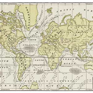
Ocean currents map 1875

![]()
Wall Art and Photo Gifts from Fine Art Storehouse
Ocean currents map 1875
The Independent Course Comprehensive Geography by James Monteith, A.S. Barnes & Co, New York & Chicago 1875
Unleash your creativity and transform your space into a visual masterpiece!
THEPALMER
Media ID 13612205
© This content is subject to copyright
Atlantic Atlantic Ocean Currents Globe Navigational Equipment Pacific Pacific Ocean Paper Tide World
FEATURES IN THESE COLLECTIONS
> Fine Art Storehouse
> The Magical World of Illustration
> Palmer Illustrated Collection
> Fine Art Storehouse
> Map
> Historical Maps
> Maps and Charts
> Early Maps
> Maps and Charts
> World
> North America
> United States of America
> Maps
> North America
> United States of America
> New York
> New York
> Maps
EDITORS COMMENTS
This print showcases an exquisite piece of history, the "Ocean currents map 1875" from James Monteith's renowned book, "The Independent Course Comprehensive Geography". Published by A. S. Barnes & Co in New York and Chicago back in 1875, this remarkable map provides a fascinating glimpse into the world's oceans during that era. Displayed horizontally on aged paper, this antique engraving beautifully illustrates the intricate network of ocean currents across the globe. The meticulously detailed cartography highlights both the Atlantic and Pacific Oceans, revealing their vastness and interconnectedness through a mesmerizing web of swirling lines. As we gaze upon this vintage masterpiece, we are transported to a time when navigational equipment relied heavily on such maps to traverse these mighty waters. It serves as a reminder of humanity's relentless pursuit to understand our planet's physical geography and harness its power for exploration and trade. "The Ocean currents map 1875" is not just an engraved image; it is a testament to human ingenuity and curiosity about our natural world. Its presence evokes feelings of awe and wonderment as we contemplate how far we have come since those early days of maritime discovery. Captured with utmost precision by THEPALMER at Fine Art Storehouse, this print preserves the essence of this historical artifact while allowing us to appreciate its beauty from afar. It stands as a timeless tribute to our ever-evolving relationship with the seas that surround us.
MADE IN AUSTRALIA
Safe Shipping with 30 Day Money Back Guarantee
FREE PERSONALISATION*
We are proud to offer a range of customisation features including Personalised Captions, Color Filters and Picture Zoom Tools
SECURE PAYMENTS
We happily accept a wide range of payment options so you can pay for the things you need in the way that is most convenient for you
* Options may vary by product and licensing agreement. Zoomed Pictures can be adjusted in the Cart.