Home > North America > United States of America > New York > New York > Maps
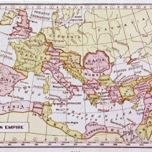
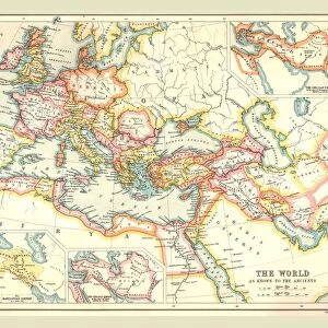
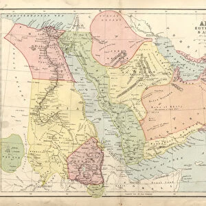
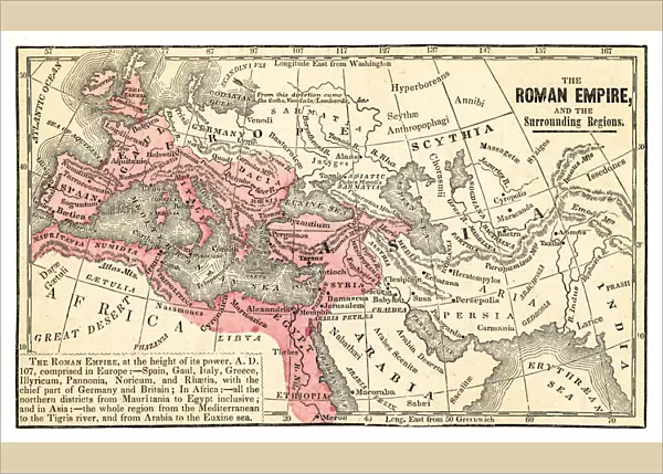
Poster Print : Roman empire map 1875


![]()
Poster Prints from Fine Art Storehouse
Roman empire map 1875
The Independent Course Comprehensive Geography by James Monteith, A.S. Barnes & Co, New York & Chicago 1875
Unleash your creativity and transform your space into a visual masterpiece!
THEPALMER
Media ID 13612221
© This content is subject to copyright
Britannia Byzantine Egypt Empire Middle East Roman Rome Byzantium Dacia Drawing Art Product
A2 (59.4 x 42cm) Poster Print
Step back in time with our Roman Empire Map 1875 print from Media Storehouse and Fine Art Storehouse. This stunning reproduction is taken from The Independent Course in Comprehensive Geography by James Monteith, published by A.S. Barnes & Co in New York and Chicago in 1875. The map, titled "THEPALMER's Map of the Roman Empire in Europe, Asia, and Africa," offers a captivating glimpse into the historical extent of the Roman Empire at a pivotal moment in world history. With intricate detail and vibrant colors, this poster print is a must-have for history enthusiasts, educators, and anyone interested in ancient civilizations. Bring the rich history of the Roman Empire into your home or office with this beautiful and informative piece.
Premium quality poster prints are printed on luxurious glossy or matte 270 gsm paper. Our meticulously crafted poster prints offer an affordable option for decorating any space, making them ideal for living rooms, bedrooms, offices and beyond. To ensure your poster arrives in good condition, we roll and send them in strong mailing tubes.
Poster prints are budget friendly enlarged prints in standard poster paper sizes (A0, A1, A2, A3 etc). Whilst poster paper is sometimes thinner and less durable than our other paper types, they are still ok for framing and should last many years. Our Archival Quality Photo Prints and Fine Art Paper Prints are printed on higher quality paper and the choice of which largely depends on your budget.
Estimated Image Size (if not cropped) is 59.6cm x 37.1cm (23.5" x 14.6")
Estimated Product Size is 59.6cm x 42.6cm (23.5" x 16.8")
These are individually made so all sizes are approximate
Artwork printed orientated as per the preview above, with landscape (horizontal) orientation to match the source image.
FEATURES IN THESE COLLECTIONS
> Africa
> Egypt
> Related Images
> Europe
> Italy
> Lazio
> Rome
> Fine Art Storehouse
> The Magical World of Illustration
> Palmer Illustrated Collection
> Fine Art Storehouse
> Map
> Historical Maps
> Historic
> Ancient civilizations
> Roman Empire
> Ancient Rome
> Historic
> Ancient civilizations
> Roman Empire
> Roman art
> Maps and Charts
> Related Images
> Maps and Charts
> Spain
> North America
> United States of America
> Maps
> North America
> United States of America
> New York
> New York
> Maps
EDITORS COMMENTS
This print showcases a historical gem, the "Roman Empire Map 1875" taken from James Monteith's renowned work, "The Independent Course Comprehensive Geography". Published in New York and Chicago by A. S. Barnes & Co. , this exquisite piece of art takes us on a visual journey through the vast territories once ruled by the mighty Roman Empire. With meticulous detail and precision, this horizontal illustration beautifully captures Britannia, Byzantium, Dacia, Egypt, Spain, and other significant regions that were part of this ancient empire. The intricate etching and engraving techniques used to create this masterpiece add depth and texture to every stroke. As we gaze upon this remarkable drawing art product by THEPALMER from Fine Art Storehouse, we are transported back in time to an era filled with grandeur and power. The map not only serves as a geographical representation but also provides valuable insights into the political boundaries of that period. From the Middle East to USA's eastern coastlines lies evidence of Rome's influence on civilization. This artwork is a testament to their expansionist ambitions and enduring legacy. It reminds us of how nature shaped these landscapes while simultaneously being transformed by human hands. Whether you're an avid history enthusiast or simply appreciate fine craftsmanship, this Roman Empire Map 1875 print is sure to captivate your imagination and transport you back in time to one of history's most influential empires - truly a treasure for any art collector or lover of antiquity.
MADE IN AUSTRALIA
Safe Shipping with 30 Day Money Back Guarantee
FREE PERSONALISATION*
We are proud to offer a range of customisation features including Personalised Captions, Color Filters and Picture Zoom Tools
SECURE PAYMENTS
We happily accept a wide range of payment options so you can pay for the things you need in the way that is most convenient for you
* Options may vary by product and licensing agreement. Zoomed Pictures can be adjusted in the Cart.