Home > North America > United States of America > New York > New York > Maps
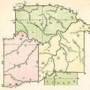
USA middle states map 1875

![]()
Wall Art and Photo Gifts from Fine Art Storehouse
USA middle states map 1875
The Independent Course Comprehensive Geography by James Monteith, A.S. Barnes & Co, New York & Chicago 1875
Unleash your creativity and transform your space into a visual masterpiece!
THEPALMER
Media ID 13612231
© This content is subject to copyright
Globe Navigational Equipment New Jersey New York New York State Ohio Paper Pennsylvania Virginia Virginia Us State West Virginia Drawing Art Product
FEATURES IN THESE COLLECTIONS
> Fine Art Storehouse
> The Magical World of Illustration
> Palmer Illustrated Collection
> Fine Art Storehouse
> Map
> Historical Maps
> Fine Art Storehouse
> Map
> USA Maps
> Maps and Charts
> Early Maps
> Maps and Charts
> World
> North America
> United States of America
> Maps
> North America
> United States of America
> New Jersey
> Related Images
> North America
> United States of America
> New York
> New York
> Maps
> North America
> United States of America
> Ohio
> Related Images
> North America
> United States of America
> Pennsylvania
> Related Images
> North America
> United States of America
> Virginia
> Related Images
> North America
> United States of America
> West Virginia
> Related Images
EDITORS COMMENTS
This print takes us back in time to the year 1875, showcasing a detailed map of the middle states of the United States. The map is an exquisite piece from "The Independent Course Comprehensive Geography" by James Monteith, published by A. S. Barnes & Co in New York and Chicago. It beautifully illustrates the states of New Jersey, New York, Ohio, Pennsylvania, Virginia, and West Virginia. The vintage charm emanating from this image transports us to an era when cartography was meticulously crafted by hand. The delicate engravings and etchings on paper showcase not only the artistry but also the significance of physical geography during that period. As we explore this antique masterpiece further, we are reminded of how maps were once vital navigational tools before modern technology took over. This particular map captures our attention with its vertical orientation and provides a unique perspective on these midwestern American states. "The USA Middle States Map 1875" serves as a testament to both historical accuracy and artistic excellence. Its presence adds character to any space it graces while inviting viewers to appreciate the rich heritage embedded within its intricate details. THEPALMER has skillfully captured this remarkable work of art for all admirers of history and cartography alike.
MADE IN AUSTRALIA
Safe Shipping with 30 Day Money Back Guarantee
FREE PERSONALISATION*
We are proud to offer a range of customisation features including Personalised Captions, Color Filters and Picture Zoom Tools
SECURE PAYMENTS
We happily accept a wide range of payment options so you can pay for the things you need in the way that is most convenient for you
* Options may vary by product and licensing agreement. Zoomed Pictures can be adjusted in the Cart.