Home > North America > United States of America > New York > New York > Maps
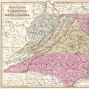
Virginia North Carolina map 1881

![]()
Wall Art and Photo Gifts from Fine Art Storehouse
Virginia North Carolina map 1881
Coltons Common School Geography 1881 New York Sheldon and Co
Unleash your creativity and transform your space into a visual masterpiece!
THEPALMER
Media ID 13669265
© This content is subject to copyright
American Culture Globe Navigational Equipment Maryland State North America North Carolina Us State Paper Planet Earth South Carolina Virginia Us State World Map
FEATURES IN THESE COLLECTIONS
> Fine Art Storehouse
> The Magical World of Illustration
> Palmer Illustrated Collection
> Fine Art Storehouse
> Map
> Historical Maps
> Fine Art Storehouse
> Map
> USA Maps
> Maps and Charts
> Early Maps
> Maps and Charts
> World
> North America
> United States of America
> Maps
> North America
> United States of America
> Maryland
> Related Images
> North America
> United States of America
> New York
> New York
> Maps
> North America
> United States of America
> North Carolina
> Related Images
> North America
> United States of America
> South Carolina
> Related Images
> North America
> United States of America
> Virginia
> Related Images
> North America
> United States of America
> West Virginia
> Related Images
EDITORS COMMENTS
This vintage map print of Virginia and North Carolina from 1881 takes us back in time to an era when cartography was a true art form. The intricate details engraved on the paper showcase the remarkable craftsmanship that went into creating this piece. As we gaze upon this historical artifact, we are transported to a bygone era, where explorers relied on maps like these to navigate the vast landscapes of North America. The map not only highlights the borders of Virginia and North Carolina but also provides a glimpse into neighboring states such as Maryland, South Carolina, and West Virginia. It serves as a reminder of how interconnected these regions were during that period. Beyond its navigational purpose, this antique map offers valuable insights into American culture and physical geography at the time. Its illustrations depict various geographical features, giving us a sense of the diverse terrain found across these states. From mountains to rivers and coastlines, it showcases the natural beauty that has shaped these regions for centuries. As we admire this timeless piece of history, let us appreciate both its artistic value and its significance in understanding our past. This print is not just an image; it represents an entire era's perspective on our planet Earth—a testament to human curiosity and exploration throughout history.
MADE IN AUSTRALIA
Safe Shipping with 30 Day Money Back Guarantee
FREE PERSONALISATION*
We are proud to offer a range of customisation features including Personalised Captions, Color Filters and Picture Zoom Tools
SECURE PAYMENTS
We happily accept a wide range of payment options so you can pay for the things you need in the way that is most convenient for you
* Options may vary by product and licensing agreement. Zoomed Pictures can be adjusted in the Cart.