Home > Maps and Charts > Early Maps
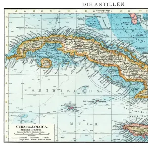
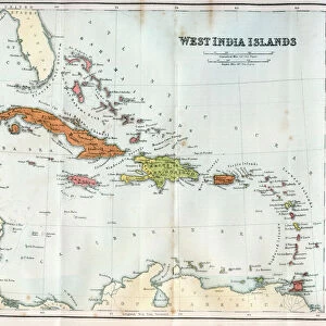
West Indies map 1855

![]()
Wall Art and Photo Gifts from Fine Art Storehouse
West Indies map 1855
System of Geography for the use of schools by Sidney E. Morse - Published by Harper & Brothers - New York 1855
Unleash your creativity and transform your space into a visual masterpiece!
THEPALMER
Media ID 13668809
© Roberto A Sanchez
Antilles Bahamas Barbados Bermuda Caribbean Sea Cuba Florida Us State Florida Usa Gulf Coast States Haiti Island Puerto Rico Textured Effect Trinidad And Tobago West Indies Obsolete
FEATURES IN THESE COLLECTIONS
> Fine Art Storehouse
> The Magical World of Illustration
> Palmer Illustrated Collection
> Fine Art Storehouse
> Map
> Historical Maps
> Maps and Charts
> Early Maps
> Maps and Charts
> World
> North America
> The Bahamas
> Maps
> North America
> Barbados
> Maps
> North America
> Bermuda
> Maps
> North America
> Cuba
> Cuba Heritage Sites
> Trinidad and the Valley de los Ingenios
> North America
> Cuba
> Maps
> North America
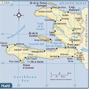
> Haiti
> Maps
> North America
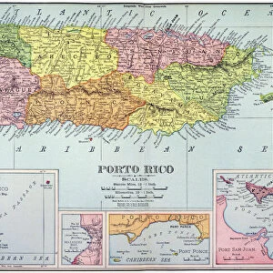
> Puerto Rico
> Maps
> North America
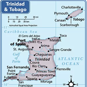
> Trinidad and Tobago
> Maps
EDITORS COMMENTS
This print takes us back in time to the year 1855, showcasing an antique map of the West Indies. The map is a part of the "System of Geography for the use of schools" by Sidney E. Morse and was published by Harper & Brothers in New York during that era. With its engraved image and textured effect, this piece exudes a sense of history and nostalgia. The intricately detailed cartography highlights various islands within the West Indies, including Trinidad and Tobago, Haiti, Bermuda, Puerto Rico, Cuba, Barbados, and many more. It provides a glimpse into the physical geography of these regions as they were perceived over 150 years ago. As we explore this old map's contours and lines, it becomes apparent how much has changed since then. Some areas have become obsolete or undergone significant transformations over time. Yet amidst these changes lies an enduring beauty that still resonates today. The horizontal composition allows us to take in every detail with ease while emphasizing the vastness of this Caribbean sea region. From Florida's Gulf Coast states to distant shores like Bahamas and Antilles - each island holds its own unique charm waiting to be explored. "The West Indies Map 1855" transports us on a journey through time; it serves as a reminder not only of our ever-changing world but also our timeless fascination with exploration and discovery.
MADE IN AUSTRALIA
Safe Shipping with 30 Day Money Back Guarantee
FREE PERSONALISATION*
We are proud to offer a range of customisation features including Personalised Captions, Color Filters and Picture Zoom Tools
SECURE PAYMENTS
We happily accept a wide range of payment options so you can pay for the things you need in the way that is most convenient for you
* Options may vary by product and licensing agreement. Zoomed Pictures can be adjusted in the Cart.