Home > Maps and Charts > Early Maps
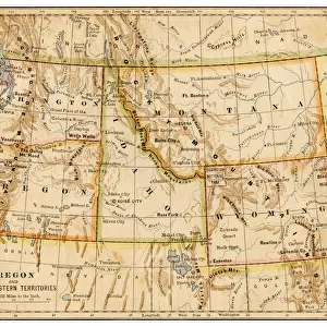
1883 United States Map

![]()
Wall Art and Photo Gifts from Fine Art Storehouse
1883 United States Map
Unleash your creativity and transform your space into a visual masterpiece!
benoitb
Media ID 20114809
© benoitb
California Great Lakes Washington West Virginia 1883
FEATURES IN THESE COLLECTIONS
> Fine Art Storehouse
> Map
> Historical Maps
> Maps and Charts
> Early Maps
EDITORS COMMENTS
This print showcases the intricate details of an 1883 United States Map, expertly crafted by the talented cartographer Benoitb. The map takes us back in time to a pivotal era in American history, offering a glimpse into the country's geographical landscape during that period. With its vintage charm and meticulous artistry, this piece is sure to captivate both history enthusiasts and admirers of fine art. The map highlights various significant regions across the nation, including West Virginia nestled amidst its neighboring states. As our eyes wander further westward, we are drawn to the majestic Great Lakes region with its interconnected waterways serving as vital trade routes. California stands out prominently on this historical canvas, symbolizing dreams of gold rush prosperity and manifest destiny. One cannot help but be intrigued by Washington state's depiction—an area rich in natural beauty and home to iconic landmarks like Mount Rainier. The level of detail captured by Benoitb transports us back to a time when exploration was paramount and cartography served as a window into uncharted territories. With its warm sepia tones and exquisite craftsmanship, this print offers more than just visual appeal; it invites us to embark on a journey through America's past. Whether displayed proudly in homes or offices or used for educational purposes, this artwork serves as a testament to our nation's ever-evolving geography while paying homage to the skillful art form of cartography.
MADE IN AUSTRALIA
Safe Shipping with 30 Day Money Back Guarantee
FREE PERSONALISATION*
We are proud to offer a range of customisation features including Personalised Captions, Color Filters and Picture Zoom Tools
SECURE PAYMENTS
We happily accept a wide range of payment options so you can pay for the things you need in the way that is most convenient for you
* Options may vary by product and licensing agreement. Zoomed Pictures can be adjusted in the Cart.