Home > Arts > Realistic drawings > Pencil drawings > Black and white artwork
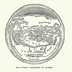
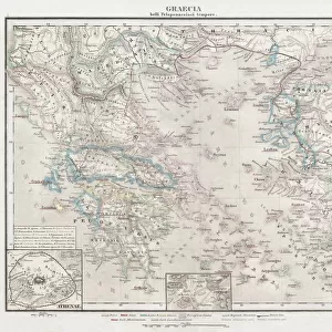
Antique illustration of VERY old world map (around year 600)
")
![]()
Wall Art and Photo Gifts from Fine Art Storehouse
Antique illustration of VERY old world map (around year 600)
Unleash your creativity and transform your space into a visual masterpiece!
ilbusca
Media ID 14757170
© ilbusca
Atlas Book Classical Greek French Culture Geographical Locations Globe Greece Greek Culture Isolated Isolated On White Pencil Drawing Retro Revival Sketch Traditional Culture Urban Scene World Map Classical Style Obsolete Painted Image Victorian Style
FEATURES IN THESE COLLECTIONS
> Africa
> Related Images
> Arts
> Realistic drawings
> Pencil drawings
> Black and white artwork
> Arts
> Realistic drawings
> Pencil drawings
> Fine art
> Arts
> Realistic drawings
> Pencil drawings
> Sketches
> Asia
> Related Images
> Fine Art Storehouse
> Map
> Historical Maps
EDITORS COMMENTS
This print takes us back in time to the ancient world with its antique illustration of a very old world map, believed to be from around the year 600. The intricate details and delicate strokes transport us to an era when cartography was still in its infancy. With a retro revival aesthetic reminiscent of 19th-century style, this atlas-like image evokes a sense of wanderlust and curiosity about the past. The painted image showcases skilled craftsmanship, resembling a sketch or pencil drawing brought to life through engraving techniques. The artwork captures the essence of antiquity, presenting an obsolete representation of physical geography. It reflects influences from classical Greek culture and Victorian styles while also hinting at French traditional culture. Famous places are marked on this black and white urban scene that spans across Asia, Greece, France, Europe, and Africa. Isolated on a white background like an artifact preserved in time, this print invites viewers to explore historical geographical locations as they were perceived centuries ago. The sea surrounding these lands connects them all within the confines of this globe-shaped depiction. Whether displayed in a book or framed on your wall, this enchanting piece by ilbusca is sure to spark conversations about history's vastness and our ever-evolving understanding of our planet's past.
MADE IN AUSTRALIA
Safe Shipping with 30 Day Money Back Guarantee
FREE PERSONALISATION*
We are proud to offer a range of customisation features including Personalised Captions, Color Filters and Picture Zoom Tools
SECURE PAYMENTS
We happily accept a wide range of payment options so you can pay for the things you need in the way that is most convenient for you
* Options may vary by product and licensing agreement. Zoomed Pictures can be adjusted in the Cart.