Home > Arts > Landscape paintings > Forest and woodland scenes > Forest artwork
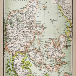
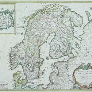
Antique map of Denmark, Norway, Sweden and Finland

![]()
Wall Art and Photo Gifts from Fine Art Storehouse
Antique map of Denmark, Norway, Sweden and Finland
Wonderful hand coloured antique map, circa 1780 - 1800
Unleash your creativity and transform your space into a visual masterpiece!
BernardAllum
Media ID 15311446
© BernardAllum
Chart Denmark Discovery Document Ephemera Exploration Finland Fjord Globe Hand Colored Harbor Individuality Norway Paper Provinces Square Sweden Travel Backgrounds Travel Locations World Map Antique Map
FEATURES IN THESE COLLECTIONS
> Arts
> Landscape paintings
> Forest and woodland scenes
> Forest artwork
> Arts
> Landscape paintings
> Waterfall and river artworks
> River artworks
> Europe
> Denmark
> Paintings
> Europe
> Finland
> Paintings
> Fine Art Storehouse
> Map
> Denmark Maps
> Fine Art Storehouse
> Map
> Historical Maps
EDITORS COMMENTS
This print showcases an exquisite antique map of Denmark, Norway, Sweden, and Finland. Created between the years 1780 and 1800, this hand-colored masterpiece is a testament to the artistry of cartography during that era. The intricate details and vibrant hues bring this historical document to life, evoking a sense of wonder and curiosity. As we gaze upon this remarkable piece, we are transported back in time to an age of exploration and discovery. Each stroke of color on the paper reveals the diverse landscapes that make up these Nordic countries – from majestic fjords to towering mountain ranges, lush forests to meandering rivers. The map also highlights important harbors and provinces within these nations. Beyond its geographical significance, this antique map symbolizes more than just physical geography; it represents individuality and cultural heritage. It serves as a reminder of our ancestors' thirst for knowledge about the world around them. The square-shaped print captures every minute detail with precision while maintaining its vintage charm. Its presence adds character to any space it graces – be it a study room or a travel enthusiast's collection. Bernard Allum has skillfully captured the essence of this antique map through his lens, preserving its beauty for generations to come. This photograph invites us on a journey through time - an opportunity to appreciate both the artistry behind cartography as well as the rich history embedded within these lands.
MADE IN AUSTRALIA
Safe Shipping with 30 Day Money Back Guarantee
FREE PERSONALISATION*
We are proud to offer a range of customisation features including Personalised Captions, Color Filters and Picture Zoom Tools
SECURE PAYMENTS
We happily accept a wide range of payment options so you can pay for the things you need in the way that is most convenient for you
* Options may vary by product and licensing agreement. Zoomed Pictures can be adjusted in the Cart.