Home > Europe > United Kingdom > Scotland > Edinburgh > Edinburgh
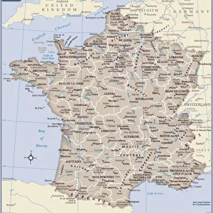
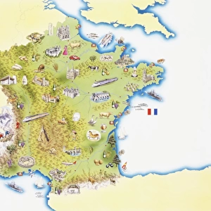
Antique map of France in Provinces, 1831

![]()
Wall Art and Photo Gifts from Fine Art Storehouse
Antique map of France in Provinces, 1831
France in Provinces by Daniel Lizars, Edinburgh 1831
The Edinburgh geographical and historical atlas, Engraved on copperplate and compiled from materials drawn from the newest and most authentic sources.
Original size Height cm: 37 Width cm: 46
Hand coloured.
Wonderful map for study of political and geographical boundaries
Unleash your creativity and transform your space into a visual masterpiece!
BernardAllum
Media ID 15311444
© Bernard Allum
FEATURES IN THESE COLLECTIONS
> Arts
> Artists
> L
> Daniel Lizars
> Europe
> United Kingdom
> Scotland
> Edinburgh
> Edinburgh
> Europe
> United Kingdom
> Scotland
> Lothian
> Edinburgh
> Fine Art Storehouse
> Map
> Historical Maps
> Maps and Charts
> Early Maps
EDITORS COMMENTS
This antique map of France in Provinces, dating back to 1831, is a true testament to the artistry and precision of cartography. Created by Daniel Lizars in Edinburgh, this exquisite piece was engraved on copperplate and meticulously compiled from the most reliable sources available at that time. Measuring 37 cm in height and 46 cm in width, this hand-colored print showcases the intricate details of France's political and geographical boundaries during the early 19th century. It offers a fascinating glimpse into the historical context of France's provinces, allowing for an enriching study of their evolution over time. The delicate coloring adds depth and character to this already remarkable map. Each stroke carefully applied by skilled hands brings life to every region depicted on its surface. Whether used as a decorative piece or as an educational tool, this map serves as a window into both past geographies and artistic craftsmanship. Bernard Allum has captured not only the beauty but also the significance of this particular print through his lens. The photograph preserves every fine detail with utmost clarity, inviting viewers to appreciate its historical value while marveling at its aesthetic appeal. For history enthusiasts or those seeking unique decor pieces with rich cultural heritage, this antique map print is sure to be a cherished addition to any collection or space it graces.
MADE IN AUSTRALIA
Safe Shipping with 30 Day Money Back Guarantee
FREE PERSONALISATION*
We are proud to offer a range of customisation features including Personalised Captions, Color Filters and Picture Zoom Tools
SECURE PAYMENTS
We happily accept a wide range of payment options so you can pay for the things you need in the way that is most convenient for you
* Options may vary by product and licensing agreement. Zoomed Pictures can be adjusted in the Cart.