Home > Maps and Charts > Americas
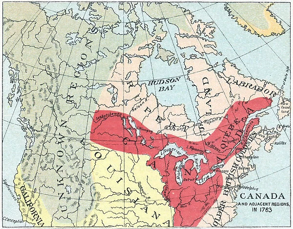
Antique Map of North America after the Seven Years War - 18th Century
![]()

Wall Art and Photo Gifts from Fine Art Storehouse
Antique Map of North America after the Seven Years War - 18th Century
Vintage map of the territories of British North America after the Seven Years War. Vintage etching circa late 19th century
Unleash your creativity and transform your space into a visual masterpiece!
powerofforever
Media ID 15149717
© This content is subject to copyright
Territory British North America
FEATURES IN THESE COLLECTIONS
> Fine Art Storehouse
> Map
> Historical Maps
> Maps and Charts
> Early Maps
> North America
> Related Images
EDITORS COMMENTS
This print showcases an exquisite antique map of North America, capturing the historical landscape after the Seven Years War in the 18th century. Crafted with meticulous detail and etched during the late 19th century, this vintage masterpiece takes us back to a time when British North America was undergoing significant territorial changes. The map reveals a fascinating glimpse into the past, highlighting various regions such as Ruppert's Land and an unknown territory that piques curiosity. Each stroke of ink on this aged parchment tells a story of exploration, conquests, and uncharted frontiers waiting to be discovered. As we immerse ourselves in this visual treasure trove, our imagination is ignited by thoughts of early settlers navigating these vast lands. The intricate borders delineate boundaries yet hint at endless possibilities for adventure and expansion. With its warm sepia tones and delicate lines, this print evokes nostalgia while reminding us of how far we have come as a society. It serves as a testament to human curiosity and resilience throughout history. Whether displayed in your study or living room, this artwork will undoubtedly spark conversations about our continent's rich heritage. Let it transport you to an era where cartography was both artistry and science—a true testament to the power of forever captured within Fine Art Storehouse's remarkable collection.
MADE IN AUSTRALIA
Safe Shipping with 30 Day Money Back Guarantee
FREE PERSONALISATION*
We are proud to offer a range of customisation features including Personalised Captions, Color Filters and Picture Zoom Tools
SECURE PAYMENTS
We happily accept a wide range of payment options so you can pay for the things you need in the way that is most convenient for you
* Options may vary by product and licensing agreement. Zoomed Pictures can be adjusted in the Cart.


