Home > Europe > United Kingdom > Wales > Denbighshire > Denbigh
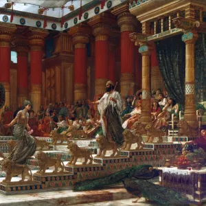
Antique map, North Wales, Anglesey, Carnarvon, 19th Century

![]()
Wall Art and Photo Gifts from Fine Art Storehouse
Antique map, North Wales, Anglesey, Carnarvon, 19th Century
Vintage engraving of a Antique map, North Wales, Anglesey, Carnarvon, Denbigh, Merionete, Montgomery19th Century
Unleash your creativity and transform your space into a visual masterpiece!
duncan1890
Media ID 15231371
© This content is subject to copyright
1890s Anglesey Colour Colours Equipment Great Britain Image Created 1890 1899 Navigational Equipment North Wales Northern Europe Retro Road Map Styles Supplies United Kingdom Victorian Wales Aberconwy And Colwyn Clwyd Conwy Denbighshire Gwynedd Obsolete
FEATURES IN THESE COLLECTIONS
> Europe
> United Kingdom
> Wales
> Anglesey
> Related Images
> Europe
> United Kingdom
> Wales
> Clwyd
> Europe
> United Kingdom
> Wales
> Conwy
> Conwy
> Europe
> United Kingdom
> Wales
> Denbighshire
> Denbigh
> Europe
> United Kingdom
> Wales
> Gwynedd
> Conwy
> Europe
> United Kingdom
> Wales
> Maps
> Europe
> United Kingdom
> Wales
> Paintings
> Fine Art Storehouse
> Map
> Historical Maps
> Maps and Charts
> Early Maps
> Maps and Charts
> Wales
EDITORS COMMENTS
This vintage engraving takes us back to the 19th century, immersing us in the rich history and charm of North Wales. The antique map showcases a meticulously detailed depiction of Anglesey, Carnarvon, Denbigh, Merionete, Montgomery and more. Created in the late 1800s, this lithograph offers a glimpse into a bygone era when navigational equipment was simpler yet essential for exploration. The colors used in this print add vibrancy to the map's intricate cartography. Every stroke tells a story of Europe's northern gem - Great Britain. As we trace our eyes across its faded lines and curves, we are transported through time to an era where road maps were cherished possessions. This image evokes nostalgia for old-fashioned styles and supplies that have become obsolete over time. It captures the essence of Victorian aesthetics while showcasing Gwynedd's historical significance within Wales' united kingdom. As we admire this piece from Duncan1890's collection at Fine Art Storehouse, it serves as a reminder that art can be found not only on canvas but also on paper. This antique map is not just an illustration; it is a window into the past—a testament to human curiosity and our desire to explore uncharted territories. Whether you are an avid collector or simply appreciate the beauty of vintage prints, this artwork will transport you back in time with its timeless appeal.
MADE IN AUSTRALIA
Safe Shipping with 30 Day Money Back Guarantee
FREE PERSONALISATION*
We are proud to offer a range of customisation features including Personalised Captions, Color Filters and Picture Zoom Tools
SECURE PAYMENTS
We happily accept a wide range of payment options so you can pay for the things you need in the way that is most convenient for you
* Options may vary by product and licensing agreement. Zoomed Pictures can be adjusted in the Cart.