Home > Europe > United Kingdom > Scotland > Scottish Borders > Selkirk
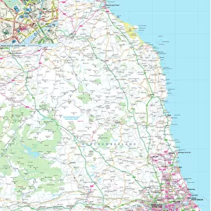
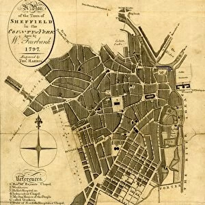
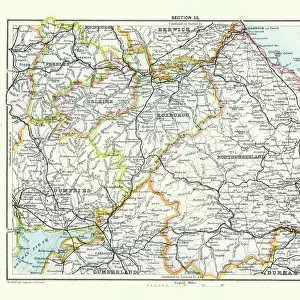
Antique map, Northumberland, Roxburgh, Cumberland 19th Century

![]()
Wall Art and Photo Gifts from Fine Art Storehouse
Antique map, Northumberland, Roxburgh, Cumberland 19th Century
Vintage engraving of a Antique map, Northumberland, Roxburgh, Cumberland, Dumfries, Selkirk, Berwick 19th Century
Unleash your creativity and transform your space into a visual masterpiece!
duncan1890
Media ID 15134757
© This content is subject to copyright
FEATURES IN THESE COLLECTIONS
> Europe
> United Kingdom
> England
> Cumberland
> Europe
> United Kingdom
> England
> Northumberland
> Related Images
> Europe
> United Kingdom
> Scotland
> Dumfries and Galloway
> Dumfries
> Europe
> United Kingdom
> Scotland
> Roxburghshire
> Europe
> United Kingdom
> Scotland
> Scottish Borders
> Selkirk
> Fine Art Storehouse
> Map
> Historical Maps
> Maps and Charts
> Early Maps
EDITORS COMMENTS
This print takes us on a journey back in time to the 19th century, immersing us in the rich history of Northumberland, Roxburgh, Cumberland, Dumfries, Selkirk, and Berwick. The vintage engraving beautifully captures the intricate details of an antique map that once guided explorers and adventurers through these enchanting regions. As we gaze upon this piece from Fine Art Storehouse titled "Antique map, Northumberland, Roxburgh, Cumberland 19th Century" we can't help but be transported to a bygone era. The delicate lines and meticulous craftsmanship evoke a sense of awe for the cartographers who painstakingly created this masterpiece. The map showcases not only geographical features but also hints at the cultural heritage and significance of these areas. It invites us to explore hidden gems tucked away within ancient castles or meander along winding rivers that have witnessed centuries of stories unfold. Duncan1890's skillful capture ensures that every minute detail is preserved with utmost clarity. From faded ink markings denoting towns and villages to elegant calligraphy labeling mountain ranges and forests – each element tells its own tale. Whether you are an avid historian or simply appreciate artistry from yesteryears, this print serves as a remarkable conversation starter for any space it graces. Let yourself be captivated by the beauty of antiquity as you delve into the fascinating world depicted within "Antique map, Northumberland, Roxburgh, Cumberland 19th Century. "
MADE IN AUSTRALIA
Safe Shipping with 30 Day Money Back Guarantee
FREE PERSONALISATION*
We are proud to offer a range of customisation features including Personalised Captions, Color Filters and Picture Zoom Tools
SECURE PAYMENTS
We happily accept a wide range of payment options so you can pay for the things you need in the way that is most convenient for you
* Options may vary by product and licensing agreement. Zoomed Pictures can be adjusted in the Cart.