Home > Europe > United Kingdom > Scotland > Strathclyde > Glasgow
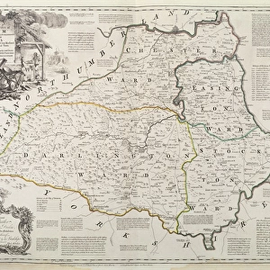
Antique map of Westmoreland

![]()
Wall Art and Photo Gifts from Fine Art Storehouse
Antique map of Westmoreland
James Bells A new and comprehensive gazetteer of England and Wales, with county maps, published in Glasgow by A. Fullarton and Co. between 1833 and 1837
Unleash your creativity and transform your space into a visual masterpiece!
BernardAllum
Media ID 18126237
© BernardAllum
Page Rustic Painted Image Parch Retro Styled
FEATURES IN THESE COLLECTIONS
> Europe
> United Kingdom
> England
> Maps
> Europe
> United Kingdom
> Scotland
> Strathclyde
> Glasgow
> Europe
> United Kingdom
> Wales
> Maps
> Fine Art Storehouse
> Map
> Historical Maps
> Maps and Charts
> Early Maps
> Maps and Charts
> Wales
EDITORS COMMENTS
This print transports us back in time to the enchanting world of cartography. The image showcases an exquisite antique map of Westmoreland, meticulously crafted by James Bell and published between 1833 and 1837. With its retro-styled aesthetic, this piece exudes a sense of nostalgia that instantly captivates the viewer. The map's intricate details are brought to life through Bernard Allum's expert photography skills, capturing every stroke and line with remarkable clarity. The painted image on this rustic page evokes a sense of history and discovery, inviting us to explore the rich tapestry of England and Wales as it was centuries ago. The aged appearance adds an authentic touch to this antique gem – its parchment-like texture tells stories untold, whispering secrets from times long gone. As we gaze upon this masterpiece, we can almost imagine ourselves embarking on a grand adventure across rolling hillsides and winding rivers. Bernard Allum's skillful composition allows us to appreciate not only the artistry behind James Bell's work but also the beauty found within vintage maps themselves. This print is more than just a decorative piece; it serves as a window into our past, reminding us of the importance of preserving history for future generations. Whether displayed in a study or adorning the walls of an art enthusiast's collection, this stunning print will undoubtedly spark conversations about exploration, craftsmanship, and our enduring fascination with antiquity.
MADE IN AUSTRALIA
Safe Shipping with 30 Day Money Back Guarantee
FREE PERSONALISATION*
We are proud to offer a range of customisation features including Personalised Captions, Color Filters and Picture Zoom Tools
SECURE PAYMENTS
We happily accept a wide range of payment options so you can pay for the things you need in the way that is most convenient for you
* Options may vary by product and licensing agreement. Zoomed Pictures can be adjusted in the Cart.