Home > Europe > United Kingdom > England > London > Boroughs > City of London
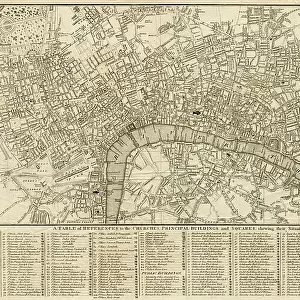
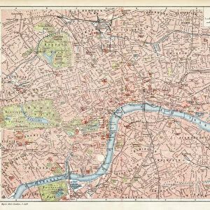
Antquie Map of London, 1895

![]()
Wall Art and Photo Gifts from Fine Art Storehouse
Antquie Map of London, 1895
illustration of Antquie Map of London, 1895
Unleash your creativity and transform your space into a visual masterpiece!
Nastasic
Media ID 13750429
© This content is subject to copyright
1880 1889 City Map City Of London Equipment Greater London Human Settlement London England Navigational Equipment Northern Europe Retro Style Road Map Southeast England Styles Thames River Obsolete Outer London Victorian Style
FEATURES IN THESE COLLECTIONS
> Arts
> Landscape paintings
> Waterfall and river artworks
> River artworks
> Europe
> United Kingdom
> England
> Greater London
> Related Images
> Europe
> United Kingdom
> England
> London
> Boroughs
> City of London
> Europe
> United Kingdom
> England
> London
> River Thames
> Europe
> United Kingdom
> England
> Maps
> Europe
> United Kingdom
> England
> Rivers
> Europe
> United Kingdom
> Maps
> Fine Art Storehouse
> Map
> Historical Maps
> Maps and Charts
> Early Maps
EDITORS COMMENTS
This print transports us back to the enchanting streets of London in 1895. The Antiquie Map of London, beautifully illustrated with intricate details and vibrant colors, captures the essence of a bygone era. As we gaze upon this horizontal image, we are reminded of the rich history that permeates every corner of this iconic city. The retro style adds an extra layer of nostalgia, evoking memories from a time long past. This color image takes us on a visual journey through Southeast England's capital, showcasing both the City of London and its outer regions. Greater London unfolds before our eyes as we explore its diverse neighborhoods and landmarks. With no people present in the engraving-like illustration, it allows us to fully immerse ourselves in this historical moment. We can almost envision Victorian-era residents navigating these streets using their trusty navigational equipment. The Thames River gracefully winds its way through the map, serving as a reminder of how integral it has been to London's development over centuries. This antique piece serves not only as a road map but also as a testament to human settlement and progress throughout time. As we admire this old engraved image brought back to life through photography techniques, we are transported into an obsolete world where cartography was an art form unto itself. Nastasic's skillful execution breathes new life into this antique treasure while preserving its authenticity for generations to come.
MADE IN AUSTRALIA
Safe Shipping with 30 Day Money Back Guarantee
FREE PERSONALISATION*
We are proud to offer a range of customisation features including Personalised Captions, Color Filters and Picture Zoom Tools
SECURE PAYMENTS
We happily accept a wide range of payment options so you can pay for the things you need in the way that is most convenient for you
* Options may vary by product and licensing agreement. Zoomed Pictures can be adjusted in the Cart.


![L&NWR Extension of Victoria Station Manchester General Plan [1880]](/sq/229/lnwr-extension-victoria-station-manchester-19234137.jpg.webp)