Home > Maps and Charts > Early Maps
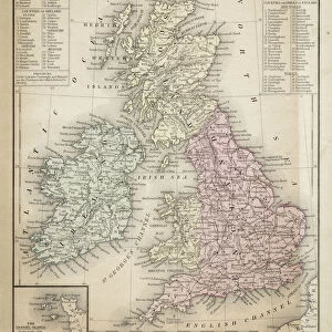
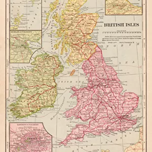
British isles map 1886

![]()
Wall Art and Photo Gifts from Fine Art Storehouse
British isles map 1886
British isles map 1886 Maps Monteith Physical Geography 1886
Unleash your creativity and transform your space into a visual masterpiece!
THEPALMER
Media ID 14549485
© This content is subject to copyright
FEATURES IN THESE COLLECTIONS
> Fine Art Storehouse
> Map
> Historical Maps
> Maps and Charts
> Early Maps
EDITORS COMMENTS
This print showcases a historical gem, the "British Isles Map 1886". A true treasure for history enthusiasts and geography aficionados alike, this piece takes us back to a time when cartography was an art form. The intricate details and meticulous craftsmanship of this map are truly awe-inspiring. The British Isles, depicted in all their glory, come alive on this vintage masterpiece. Every contour of the landmasses is delicately etched onto the paper, capturing the essence of these enchanting islands. From England's rolling hills to Scotland's rugged landscapes and Ireland's breathtaking coastlines, every inch of this map tells a story. Dating back to 1886, it offers us a glimpse into an era where exploration and discovery were at their peak. As we gaze upon its faded hues and aged parchment-like texture, we can't help but imagine the excitement that must have filled those who first laid eyes on it over a century ago. "The Palmer" known for their expertise in preserving historical artifacts through photography prints like this one from Fine Art Storehouse, has done justice to this remarkable piece. Their attention to detail ensures that every line and symbol retains its original charm while being beautifully presented for contemporary audiences. Whether you're seeking inspiration or simply appreciate the beauty of maps as works of art themselves, "British Isles Map 1886" will transport you through time with its rich history and undeniable allure.
MADE IN AUSTRALIA
Safe Shipping with 30 Day Money Back Guarantee
FREE PERSONALISATION*
We are proud to offer a range of customisation features including Personalised Captions, Color Filters and Picture Zoom Tools
SECURE PAYMENTS
We happily accept a wide range of payment options so you can pay for the things you need in the way that is most convenient for you
* Options may vary by product and licensing agreement. Zoomed Pictures can be adjusted in the Cart.