Home > Maps and Charts > Early Maps
Chinese and Japanese Empires

![]()
Wall Art and Photo Gifts from Fine Art Storehouse
Chinese and Japanese Empires
Antique Maps, TR002315
Unleash your creativity and transform your space into a visual masterpiece!
Fototeca Gilardi
Media ID 18443293
FEATURES IN THESE COLLECTIONS
> Fine Art Storehouse
> Map
> Historical Maps
> Maps and Charts
> Early Maps
EDITORS COMMENTS
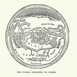
This print titled "Chinese and Japanese Empires (Antique Maps, TR002315)" takes us on a visual journey through time, offering a glimpse into the rich history of two ancient empires. The image showcases intricate antique maps that beautifully depict the Chinese and Japanese territories. As we gaze upon this artwork from Fine Art Storehouse's collection, we are transported to an era where cartography was both an art form and a scientific endeavor. The level of detail in these maps is awe-inspiring; every mountain range, river, and city is meticulously illustrated with remarkable precision. The Chinese Empire map reveals the vast expanse of its territory, showcasing its diverse landscapes from the majestic Great Wall snaking across mountains to bustling cities like Beijing and Shanghai. Meanwhile, the Japanese Empire map highlights Japan's archipelago with its iconic Mount Fuji majestically rising above serene coastal towns. Through this print by Fototeca Gilardi, we not only appreciate the artistic beauty but also gain insight into historical geopolitics. It serves as a reminder of how these empires shaped their respective regions and influenced global affairs for centuries. Whether you are an avid historian or simply captivated by vintage aesthetics, this stunning artwork will undoubtedly add depth and intrigue to any space it graces. Let it transport you back in time as you explore the intricacies of these ancient empires captured within this extraordinary piece.
MADE IN AUSTRALIA
Safe Shipping with 30 Day Money Back Guarantee
FREE PERSONALISATION*
We are proud to offer a range of customisation features including Personalised Captions, Color Filters and Picture Zoom Tools
SECURE PAYMENTS
We happily accept a wide range of payment options so you can pay for the things you need in the way that is most convenient for you
* Options may vary by product and licensing agreement. Zoomed Pictures can be adjusted in the Cart.