Home > North America > United States of America > New York > New York > Maps
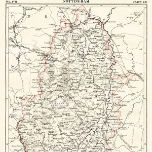
Cumberland map 1884

![]()
Wall Art and Photo Gifts from Fine Art Storehouse
Cumberland map 1884
Encyclopedia Britannica 9th Edition New York Charles Scribners and Sons 1884 Vol VI
Unleash your creativity and transform your space into a visual masterpiece!
THEPALMER
Media ID 14549437
© This content is subject to copyright
FEATURES IN THESE COLLECTIONS
> Europe
> United Kingdom
> England
> Cumberland
> Fine Art Storehouse
> Map
> Historical Maps
> Maps and Charts
> Early Maps
> North America
> United States of America
> New York
> New York
> Maps
EDITORS COMMENTS
In this photo print, titled "Cumberland map 1884" we are transported back in time to the late 19th century. The image showcases a meticulously detailed map from the Encyclopedia Britannica's 9th Edition, published by Charles Scribners and Sons in New York. Vol VI of this esteemed encyclopedia takes us on a visual journey through Cumberland, Great Britain. The map itself is a testament to the artistry and precision of cartography during that era. Every contour line, river bend, and road network is intricately depicted with remarkable accuracy. It serves as both an informative tool for geographical exploration and a beautiful work of art. As we delve into this historical gem captured by THEPALMER at Fine Art Storehouse, our imagination runs wild with thoughts of explorers tracing their fingers along these very same lines over a century ago. We can almost hear the rustle of pages turning as eager minds sought knowledge within its pages. This photograph not only preserves an important piece of history but also invites us to reflect upon how far we have come since then. It reminds us that maps were once cherished possessions that held vast amounts of information within their inked borders. "The Cumberland map 1884" print transports us back in time while simultaneously reminding us to appreciate the advancements made throughout history. It stands as a testament to human curiosity and our unending quest for knowledge about the world around us.
MADE IN AUSTRALIA
Safe Shipping with 30 Day Money Back Guarantee
FREE PERSONALISATION*
We are proud to offer a range of customisation features including Personalised Captions, Color Filters and Picture Zoom Tools
SECURE PAYMENTS
We happily accept a wide range of payment options so you can pay for the things you need in the way that is most convenient for you
* Options may vary by product and licensing agreement. Zoomed Pictures can be adjusted in the Cart.