Home > Europe > United Kingdom > England > Sussex > Bognor Regis
Hand coloured antique map of Sussex England

![]()
Wall Art and Photo Gifts from Fine Art Storehouse
Hand coloured antique map of Sussex England
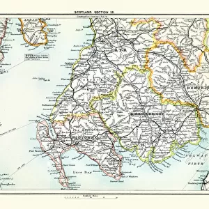
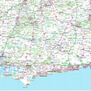
This detailed map of Sussex is from Dugdales England and Wales Delineated. The map was drawn by G.Cole and engraved by John Roper for publication first in The Beauties Of England And Wales, The maps show accurate geographical detail, including the turnpike, mail coach and principal roads, sites of Roman and other historical remains, as well as the seats of the nobility and the gentry, and market towns with their distances from London
Unleash your creativity and transform your space into a visual masterpiece!
BernardAllum
Media ID 15311438
© BernardAllum
Backgrounds Brighton British Culture Cartouche Document English Channel Frame Grunge Hand Colored Island Kent Paper Picture Frame Republic Of Ireland Retro Revival Stained Surrey Sussex Textured Effect Bognor Regis Obsolete
FEATURES IN THESE COLLECTIONS
> Arts
> Photorealistic artworks
> Detailed art pieces
> Masterful detailing in art
> Europe
> Republic of Ireland
> Maps
> Europe
> United Kingdom
> England
> Brighton & Hove
> Europe
> United Kingdom
> England
> Kent
> Related Images
> Europe
> United Kingdom
> England
> London
> Fashion
> Europe
> United Kingdom
> England
> Maps
> Europe
> United Kingdom
> England
> Surrey
> Related Images
> Europe
> United Kingdom
> England
> Sussex
> Bognor Regis
> Europe
> United Kingdom
> England
> Sussex
> Brighton
> Europe
> United Kingdom
> England
> Sussex
> Hastings
> Fine Art Storehouse
> The Great British Seaside
> Bognor Regis
> Fine Art Storehouse
> Map
> Historical Maps
EDITORS COMMENTS
This hand-coloured antique map of Sussex, England is a true masterpiece that takes us back in time. Taken from Dugdales England and Wales Delineated, this detailed map showcases the remarkable skills of G. Cole as the artist and John Roper as the engraver. Originally published in The Beauties Of England And Wales, it provides an accurate representation of geographical features such as turnpikes, mail coach routes, principal roads, Roman remains, noble estates and market towns with their distances from London. The retro revival charm emanating from this print transports us to a bygone era when cartography was both an art form and a scientific endeavor. The stained paper adds character to the piece while the textured effect gives it depth and authenticity. As we gaze at this framed treasure on our wall, we are reminded of British culture's rich history and its connection to physical geography. From Hastings to Brighton, Bognor Regis to Kent and Surrey - all these places come alive on this beautifully crafted map. It even includes details about the English Channel separating Sussex from mainland Europe. Bernard Allum has truly captured the essence of this historic document through his expert photography skills. This print serves as a reminder of how far we have come in terms of mapping technology while also celebrating the beauty found within old-fashioned cartography techniques.
MADE IN AUSTRALIA
Safe Shipping with 30 Day Money Back Guarantee
FREE PERSONALISATION*
We are proud to offer a range of customisation features including Personalised Captions, Color Filters and Picture Zoom Tools
SECURE PAYMENTS
We happily accept a wide range of payment options so you can pay for the things you need in the way that is most convenient for you
* Options may vary by product and licensing agreement. Zoomed Pictures can be adjusted in the Cart.